
Lake Worth Beach topographic map
Interactive map
Click on the map to display elevation.
Lake Worth Beach
Lake Worth Beach is located at 26°37′11″N 80°3′31″W / 26.61972°N 80.05861°W / 26.61972; -80.05861, bordering West Palm Beach to the north, Lake Clarke Shores to the northeast, and Lantana to the south. The municipal beach section of the city borders Palm Beach, while Lake Worth Beach is also located just east of Palm Springs. Lake Worth Beach is located about 64 miles (103 km) north of Miami. According to the United States Census Bureau, the city has a total area of 6.81 square miles (18 km2), of which 5.89 square miles (15 km2) is land and 0.92 square miles (2 km2) (13.51%) is water. The average elevation of Lake Worth Beach is 16 ft (4.9 m).
About this map
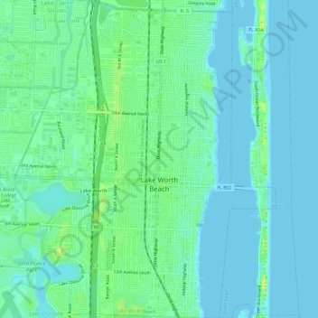
Name: Lake Worth Beach topographic map, elevation, terrain.
Average elevation: 20 ft
Minimum elevation: -10 ft
Maximum elevation: 56 ft
Palm Beach County trails, hiking, mountain biking, running and outdoor activities
Other topographic maps
Click on a map to view its topography, its elevation and its terrain.
Villages of Oriole
United States > Florida > Palm Beach County > Villages of Oriole
Average elevation: 30 ft
Delray Beach
United States > Florida > Palm Beach County > Delray Beach
Delray Beach has hot and humid summers. High summertime temperatures range from 87-93 °F with low temperatures around 75-78 °F. Winters are warm, with a marked drier season. Typical wintertime high temperatures are typically in the range of 74-83 °F and low temperatures 57-65 °F. However, when occasional…
Average elevation: 13 ft
Oslo national park
United States > Florida > Palm Beach County > West Palm Beach
Average elevation: 30 ft
Blue Inlet
United States > Florida > Palm Beach County > Boca Raton > Blue Inlet
Average elevation: 13 ft
Palm Beach Lakes
United States > Florida > Palm Beach County > West Palm Beach
Average elevation: 26 ft