
Cache La Poudre Wilderness topographic map
Click on the map to display elevation.
Cache La Poudre Wilderness
The Cache la Poudre Wilderness is federally-protected area administered by the U.S. Forest Service, a division of the U.S. Department of Agriculture. It is located on the Canyon Lakes Ranger District on the Roosevelt National Forest in Colorado. This wilderness covers 9,258 acres (37.47 km2) and is characterized by steep, rugged terrain along the Cache la Poudre River. Elevations in this area varies from 6,200 feet (1,900 m) to 8,600 feet (2,600 m). Only one trail, the Mount McConnel National Recreation Trail that is 3 miles (4.8 km) long, exists in this wilderness, and 9 miles (14 km) of the Little South Fork of the Cache La Poudre River flow through the wilderness.
About this map
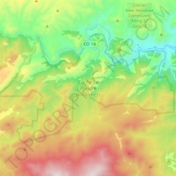
Name: Cache La Poudre Wilderness topographic map, elevation, terrain.
Average elevation: 7,720 ft
Minimum elevation: 6,027 ft
Maximum elevation: 10,177 ft
Other topographic maps
Click on a map to view its topography, its elevation and its terrain.
Estes Park
United States > Colorado > Larimer County
Estes Park sits at an elevation of 7,522 feet (2,293 m) on the front range of the Rocky Mountains at the eastern entrance of the Rocky Mountain National Park. Its north, south and east extremities border the Roosevelt National Forest. Lumpy Ridge lies immediately north of Estes Park.
Average elevation: 8,343 ft
Estes Park
United States > Colorado > Larimer County
Estes Park sits at an elevation of 7,522 feet (2,293 m) on the front range of the Rocky Mountains at the eastern entrance of the Rocky Mountain National Park. Its north, south and east extremities border the Roosevelt National Forest. Lumpy Ridge lies immediately north of Estes Park.
Average elevation: 7,940 ft
Estes Park
United States > Colorado > Larimer County
Estes Park sits at an elevation of 7,522 feet (2,293 m) on the front range of the Rocky Mountains at the eastern entrance of the Rocky Mountain National Park. Its location is 40°22′22″N 105°31′09″W / 40.372856°N 105.519136°W / 40.372856; -105.519136. Its north, south and east extremities…
Average elevation: 8,343 ft
Estes Park
United States > Colorado > Larimer County
Estes Park sits at an elevation of 7,522 feet (2,293 m) on the front range of the Rocky Mountains at the eastern entrance of the Rocky Mountain National Park. Its location is 40°22′22″N 105°31′09″W / 40.372856°N 105.519136°W / 40.372856; -105.519136. Its north, south and east extremities…
Average elevation: 7,904 ft
Stanley Heights Subdivision
United States > Colorado > Larimer County > Estes Park
Average elevation: 7,694 ft
Silver Lake
United States > Colorado > Larimer County > Loveland > Browns Corner
Average elevation: 5,000 ft
La Poudre Pass
United States > Colorado > Larimer County
La Poudre Pass (elevation 10,184 ft (3,104 m)), a high mountain pass, is located in the Rocky Mountains of northern Colorado in the United States.
Average elevation: 10,558 ft
La Poudre Pass
United States > Colorado > Larimer County
La Poudre Pass (elevation 10,184 ft (3,104 m)), a high mountain pass, is located in the Rocky Mountains of northern Colorado in the United States.
Average elevation: 10,558 ft
Horseshoe Lake (South Dam)
United States > Colorado > Larimer County > Loveland
Average elevation: 4,970 ft
Estes Park
United States > Colorado > Larimer County > Estes Park > Estes Park
Average elevation: 8,074 ft
Estes Park
United States > Colorado > Larimer County
Estes Park sits at an elevation of 7,658 feet (2,334 m) on the Front Range of the Rocky Mountains at the eastern entrance of the Rocky Mountain National Park. Its north, south and east extremities border the Roosevelt National Forest. Lumpy Ridge lies immediately north of Estes Park.
Average elevation: 8,343 ft
Estes Park
United States > Colorado > Larimer County
Estes Park sits at an elevation of 7,522 feet (2,293 m) on the front range of the Rocky Mountains at the eastern entrance of the Rocky Mountain National Park. Its north, south and east extremities border the Roosevelt National Forest. Lumpy Ridge lies immediately north of Estes Park.
Average elevation: 7,969 ft
Stanley Heights Subdivision
United States > Colorado > Larimer County > Estes Park
Average elevation: 7,694 ft