Geolocate

Adel topographic map

Click on the map to display elevation.

About this map

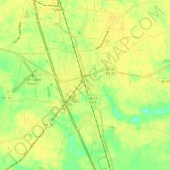
Name: Adel topographic map, elevation, terrain.

Location: Adel, Cook County, Georgia, 31620, United States (31.09444 -83.46221 31.17117 -83.39735)

Average elevation: 236 ft

Minimum elevation: 187 ft

Maximum elevation: 259 ft

Cook County trails, hiking, mountain biking, running and outdoor activities

Other topographic maps

Click on a map to view its topography, its elevation and its terrain.

Cecil

United States > Georgia > Cook County

Average elevation: 226 ft

Lenox

United States > Georgia > Cook County

Average elevation: 272 ft

Pine Valley

United States > Georgia > Cook County

Average elevation: 220 ft

Gear up for your next adventure:

🦶Hiking Gaiters - Keep debris and water out of your boots
🔥Plasma Lighters - Windproof lighters that work in any weather condition
🧺Microfiber Travel Towels - Compact and fast-drying towels for trail use
🔦Powerful Headlamps - Ultra-bright hands-free lighting for night navigation
🧣Merino Neck Gaiters - Multi-functional headwear for wind and sun protection

As an Amazon Associate, this site earns from qualifying purchases at no extra cost to you.