
Make a donation
Gear up for your next adventure:
As an Amazon Associate, this site earns from qualifying purchases at no extra cost to you.
Brielen topographic map
Click on the map to display elevation.
Make a donation
Gear up for your next adventure:
As an Amazon Associate, this site earns from qualifying purchases at no extra cost to you.
Brielen
Brielen is een lintdorp met bebouwing uit de jaren '20 van de 20e eeuw. Tussen het kasteel en het dorp werd later een wijk in sociale woningbouw opgericht. Brielen ligt op ongeveer 20 meter hoogte in Zandlemig Vlaanderen. In het oosten vindt men de Ieperlee, in het westen vindt men de Wanebeek, die ook de grachten van het kasteel voedt.
Make a donation
Gear up for your next adventure:
As an Amazon Associate, this site earns from qualifying purchases at no extra cost to you.
About this map
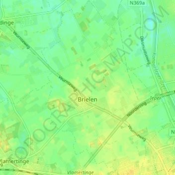
Name: Brielen topographic map, elevation, terrain.
Location: Brielen, Ieper, West-Vlaanderen, België (50.85235 2.83145 50.89060 2.88064)
Average elevation: 49 ft
Minimum elevation: 16 ft
Maximum elevation: 82 ft
Make a donation
Gear up for your next adventure:
As an Amazon Associate, this site earns from qualifying purchases at no extra cost to you.
Other topographic maps
Click on a map to view its topography, its elevation and its terrain.
Make a donation
Gear up for your next adventure:
As an Amazon Associate, this site earns from qualifying purchases at no extra cost to you.