Geolocate

Bluford topographic map

Click on the map to display elevation.

About this map

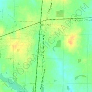
Name: Bluford topographic map, elevation, terrain.

Location: Bluford, Jefferson County, Illinois, United States (38.31320 -88.75188 38.33568 -88.71652)

Average elevation: 505 ft

Minimum elevation: 456 ft

Maximum elevation: 558 ft

Jefferson County trails, hiking, mountain biking, running and outdoor activities

Other topographic maps

Click on a map to view its topography, its elevation and its terrain.

Superior Lake

United States > Illinois > Jefferson County

Average elevation: 525 ft

Texico

United States > Illinois > Jefferson County

Average elevation: 548 ft

Gear up for your next adventure:

🥤Water Filter Bottle - All‑in‑one filter bottle for safe hydration
🧢Outdoor Hiking Hat - Sun protection hat for outdoor explorers
☀️Outdoor Sunscreen - High protection sunscreen for outdoor activities
🪶Wildlife Field Guides - Learn animal tracking and species ID
🎒Outdoor Daypacks - Lightweight backpacks designed for carrying maps and essential gear

As an Amazon Associate, this site earns from qualifying purchases at no extra cost to you.