Geolocate

Texico topographic map

Click on the map to display elevation.

About this map

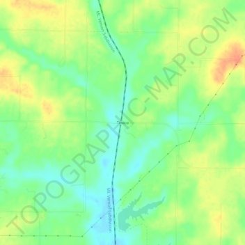
Name: Texico topographic map, elevation, terrain.

Location: Texico, Jefferson County, Illinois, United States (38.41949 -88.91701 38.45949 -88.87701)

Average elevation: 548 ft

Minimum elevation: 486 ft

Maximum elevation: 620 ft

Jefferson County trails, hiking, mountain biking, running and outdoor activities

Other topographic maps

Click on a map to view its topography, its elevation and its terrain.

Ina

United States > Illinois > Jefferson County

Average elevation: 427 ft

Bluford

United States > Illinois > Jefferson County

Average elevation: 505 ft

Belle Rive

United States > Illinois > Jefferson County

Average elevation: 463 ft

Waltonville

United States > Illinois > Jefferson County

Average elevation: 453 ft

Dix

United States > Illinois > Jefferson County

Average elevation: 571 ft

Woodlawn

United States > Illinois > Jefferson County

Average elevation: 489 ft

Superior Lake

United States > Illinois > Jefferson County

Average elevation: 525 ft

Bonnie

United States > Illinois > Jefferson County

Average elevation: 430 ft

Gear up for your next adventure:

🛏️Cold Weather Sleeping Bag - Warm sleeping bag for cold conditions
🕶️Glacier Sunglasses - Side shields to protect eyes from high-altitude snow glare
🛠️Outdoor Gear Repair Kit - Essential tools to fix gear on the trail
📻Weather Alert Radios - Stay informed of storm risks while off-the-grid
🧭Map Reading Tools - Tools and kits for map navigation

As an Amazon Associate, this site earns from qualifying purchases at no extra cost to you.