
Dawson topographic map
Click on the map to display elevation.
About this map
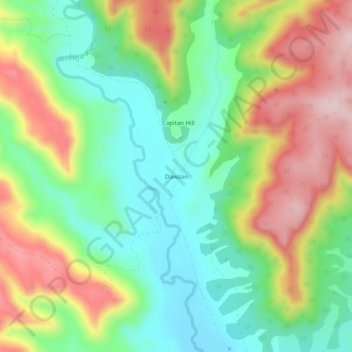
Name: Dawson topographic map, elevation, terrain.
Location: Dawson, Colfax County, New Mexico, United States (36.64420 -104.79472 36.68420 -104.75472)
Average elevation: 6,670 ft
Minimum elevation: 6,273 ft
Maximum elevation: 7,241 ft
Colfax County trails, hiking, mountain biking, running and outdoor activities
Other topographic maps
Click on a map to view its topography, its elevation and its terrain.