Geolocate

Maxwell topographic map

Click on the map to display elevation.

About this map
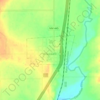
Name: Maxwell topographic map, elevation, terrain.

Location: Maxwell, Colfax County, New Mexico, United States (36.53707 -104.55115 36.54510 -104.53495)

Average elevation: 5,922 ft

Minimum elevation: 5,860 ft

Maximum elevation: 5,974 ft

Colfax County trails, hiking, mountain biking, running and outdoor activities

Other topographic maps

Click on a map to view its topography, its elevation and its terrain.
Sugarite

United States > New Mexico > Colfax County

Average elevation: 7,635 ft

Dawson

United States > New Mexico > Colfax County

Average elevation: 6,670 ft

Pinon Hills

United States > New Mexico > Colfax County

Average elevation: 6,299 ft

Urraca Mesa

United States > New Mexico > Colfax County

Average elevation: 7,861 ft

Trail Peak

United States > New Mexico > Colfax County

Average elevation: 9,193 ft

Raton Pass

United States > New Mexico > Colfax County

Ratón Pass is a 7,834 ft (2,388 m) elevation mountain pass on the Colorado–New Mexico border in the western United States. It is located on the eastern side of the Sangre de Cristo Mountains between Trinidad, Colorado and Raton, New Mexico, approximately 180 miles (290 km) northeast of Santa Fe. Ratón is…

Average elevation: 7,867 ft
Cimmaron River

United States > New Mexico > Colfax County

Average elevation: 8,635 ft

Baldy Mountain

United States > New Mexico > Colfax County

Average elevation: 11,276 ft

Bear Mountain

United States > New Mexico > Colfax County

Average elevation: 9,701 ft

Gear up for your next adventure:

🔌USB Car Charger - Car charger for on‑the‑go power needs
📦Gear Storage Bags - Organize and protect outdoor equipment
📶Vehicle Signal Boosters - Improve reception in rural areas while driving to trailheads
📡GPS Antenna Upgrade - Enhance GPS reception in remote terrain
GPS Sports Watch - GPS watch for running, hiking and training

As an Amazon Associate, this site earns from qualifying purchases at no extra cost to you.