Geolocate

清州镇 topographic map

Interactive map

Click on the map to display elevation.

About this map

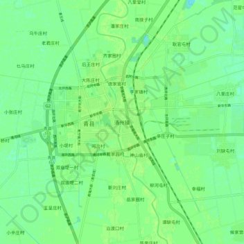
Name: 清州镇 topographic map, elevation, terrain.

Location: 清州镇, 沧州市, 河北省, 061000, 中国 (38.53466 116.78605 38.61466 116.86605)

Average elevation: 26 ft

Minimum elevation: 7 ft

Maximum elevation: 39 ft

Other topographic maps

Click on a map to view its topography, its elevation and its terrain.

淮镇

中国 > 河北省 > 沧州市

淮镇, 沧州市, 河北省, 061000, 中国

Average elevation: 43 ft

旧张屯村

中国 > 河北省 > 沧州市

旧张屯村, 沧州市, 河北省, 061000, 中国

Average elevation: 23 ft

林庄村

中国 > 河北省 > 沧州市

林庄村, 沧州市, 河北省, 061000, 中国

Average elevation: 39 ft

边西村

中国 > 河北省 > 沧州市

边西村, 沧州市, 河北省, 061000, 中国

Average elevation: 59 ft

新华区

中国 > 河北省 > 沧州市

新华区, 沧州市, 河北省, 061000, 中国

Average elevation: 30 ft

大杨村

中国 > 河北省 > 沧州市

大杨村, 沧州市, 河北省, 061000, 中国

Average elevation: 23 ft

张官屯乡

中国 > 河北省 > 沧州市

张官屯乡, 沧县, 沧州市, 河北省, 061000, 中国

Average elevation: 36 ft

李刘堡村

中国 > 河北省 > 沧州市

李刘堡村, 沧州市, 河北省, 061000, 中国

Average elevation: 10 ft

大宁村

中国 > 河北省 > 沧州市

大宁村, 沧州市, 河北省, 061000, 中国

Average elevation: 46 ft

东光县

中国 > 河北省 > 沧州市

东光县, 沧州市, 河北省, 061600, 中国

Average elevation: 46 ft

南皮县

中国 > 河北省 > 沧州市

南皮县, 沧州市, 河北省, 061500, 中国

Average elevation: 39 ft

盐山县

中国 > 河北省 > 沧州市

盐山县, 沧州市, 河北省, 061300, 中国

Average elevation: 33 ft

沧州市

中国 > 河北省 > 沧州市

沧州市, 河北省, 061000, 中国

Average elevation: 30 ft

殷家庄村

中国 > 河北省 > 沧州市

殷家庄村, 沧州市, 河北省, 061000, 中国

Average elevation: 33 ft