Geolocate

Athens topographic map

Click on the map to display elevation.

About this map

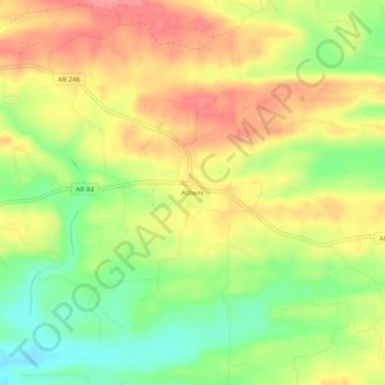
Name: Athens topographic map, elevation, terrain.

Location: Athens, Howard County, Arkansas, 71971, United States (34.29455 -93.99686 34.33455 -93.95686)

Average elevation: 932 ft

Minimum elevation: 778 ft

Maximum elevation: 1,073 ft

Howard County trails, hiking, mountain biking, running and outdoor activities

Other topographic maps

Click on a map to view its topography, its elevation and its terrain.

Tollette

United States > Arkansas > Howard County

Average elevation: 331 ft

Nashville

United States > Arkansas > Howard County

Average elevation: 420 ft

Gear up for your next adventure:

📡Handheld GPS Device - Reliable handheld GPS for outdoor navigation
💧Water Purification System - Clean water on the trail with reliable purifiers
🛶Inflatable Kayak - Portable kayak for rivers, lakes, and expeditions
🪶Trail Camera - Capture wildlife on your hikes
🪶Fire Starter Kit - Reliable fire starter for survival and camping

As an Amazon Associate, this site earns from qualifying purchases at no extra cost to you.