Geolocate

Tollette topographic map

Click on the map to display elevation.

About this map

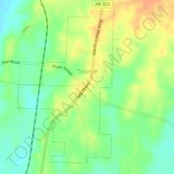
Name: Tollette topographic map, elevation, terrain.

Location: Tollette, Howard County, Arkansas, 71851, United States (33.80649 -93.90807 33.83023 -93.89014)

Average elevation: 331 ft

Minimum elevation: 276 ft

Maximum elevation: 390 ft

Howard County trails, hiking, mountain biking, running and outdoor activities

Other topographic maps

Click on a map to view its topography, its elevation and its terrain.

Umpire

United States > Arkansas > Howard County

Average elevation: 853 ft

Schaal

United States > Arkansas > Howard County

Average elevation: 299 ft

Okay

United States > Arkansas > Howard County

Average elevation: 295 ft

Center Point

United States > Arkansas > Howard County

Average elevation: 623 ft

Saratoga

United States > Arkansas > Howard County

Average elevation: 348 ft

Athens

United States > Arkansas > Howard County

Average elevation: 932 ft

Corinth

United States > Arkansas > Howard County

Average elevation: 627 ft

Midway

United States > Arkansas > Howard County

Average elevation: 344 ft

Mineola

United States > Arkansas > Howard County

Average elevation: 951 ft

Gear up for your next adventure:

🧴Hand Sanitizer - Keep hands clean while hiking
🛰️Handheld GPS Units - Professional satellite navigators for precise backcountry mapping
🛰️Satellite Messengers - Emergency SOS and two-way messaging for off-grid adventures
🔥Plasma Lighters - Windproof lighters that work in any weather condition
🪑Portable Camp Table - Compact table for campsite meals

As an Amazon Associate, this site earns from qualifying purchases at no extra cost to you.