Make a donation
Gear up for your next adventure:
As an Amazon Associate, this site earns from qualifying purchases at no extra cost to you.
Legnano topographic map
Click on the map to display elevation.
Make a donation
Gear up for your next adventure:
As an Amazon Associate, this site earns from qualifying purchases at no extra cost to you.
Legnano
Located in the south of the Varese Prealps along the Olona valley [it], the comune of Legnano has an area of 12.72 square kilometers (4.91 sq mi), has an elevation of 192–227 meters (630–745 ft) above sea level, and is seismically classified [it] in Zone 4 (Irrelevant seismology).
Make a donation
Gear up for your next adventure:
As an Amazon Associate, this site earns from qualifying purchases at no extra cost to you.
About this map
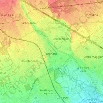
Name: Legnano topographic map, elevation, terrain.
Location: Legnano, Milan, Lombardy, 20025, Italy (45.56800 8.86561 45.62361 8.94635)
Average elevation: 689 ft
Minimum elevation: 597 ft
Maximum elevation: 778 ft
Make a donation
Gear up for your next adventure:
As an Amazon Associate, this site earns from qualifying purchases at no extra cost to you.
Other topographic maps
Click on a map to view its topography, its elevation and its terrain.
Make a donation
Gear up for your next adventure:
As an Amazon Associate, this site earns from qualifying purchases at no extra cost to you.
Make a donation
Gear up for your next adventure:
As an Amazon Associate, this site earns from qualifying purchases at no extra cost to you.
