Geolocate

Zuehl topographic map

Click on the map to display elevation.

About this map

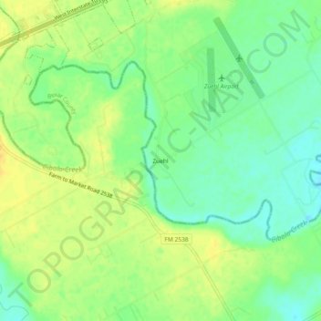
Name: Zuehl topographic map, elevation, terrain.

Location: Zuehl, Guadalupe County, Texas, United States (29.46551 -98.18612 29.50551 -98.14612)

Average elevation: 600 ft

Minimum elevation: 554 ft

Maximum elevation: 646 ft

Guadalupe County trails, hiking, mountain biking, running and outdoor activities

Other topographic maps

Click on a map to view its topography, its elevation and its terrain.

Santa Clara

United States > Texas > Guadalupe County

Average elevation: 719 ft

New Berlin

United States > Texas > Guadalupe County

Average elevation: 558 ft

Marion

United States > Texas > Guadalupe County

Average elevation: 640 ft

Kingsbury

United States > Texas > Guadalupe County > Kingsbury

Average elevation: 545 ft

Gear up for your next adventure:

🧭Map Reading Tools - Tools and kits for map navigation
🎒Trail Energy Bars - High‑calorie bars for hiking energy
🛶Inflatable Kayak - Portable kayak for rivers, lakes, and expeditions
🌡️Portable Weather Meter - Track weather conditions on the trail
🔦LED Headlamp - Bright and durable LED headlamp for night navigation

As an Amazon Associate, this site earns from qualifying purchases at no extra cost to you.