Geolocate

Marion topographic map

Click on the map to display elevation.

About this map

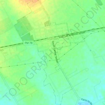
Name: Marion topographic map, elevation, terrain.

Location: Marion, Guadalupe County, Texas, United States (29.55314 -98.15377 29.58196 -98.12748)

Average elevation: 640 ft

Minimum elevation: 594 ft

Maximum elevation: 699 ft

Guadalupe County trails, hiking, mountain biking, running and outdoor activities

Other topographic maps

Click on a map to view its topography, its elevation and its terrain.

Geronimo

United States > Texas > Guadalupe County

Average elevation: 591 ft

Zorn

United States > Texas > Guadalupe County

Average elevation: 554 ft

Barbarosa

United States > Texas > Guadalupe County

Average elevation: 636 ft

Redwood

United States > Texas > Guadalupe County

Average elevation: 597 ft

Zuehl

United States > Texas > Guadalupe County

Average elevation: 600 ft

McQueeney

United States > Texas > Guadalupe County

Average elevation: 558 ft

Lake Dunlap

United States > Texas > Guadalupe County

Average elevation: 617 ft

Kingsbury

United States > Texas > Guadalupe County

Average elevation: 587 ft

Sweet Home

United States > Texas > Guadalupe County

Average elevation: 545 ft

Schertz

United States > Texas > Guadalupe County > Schertz

Average elevation: 755 ft

Gear up for your next adventure:

💧Water Purification System - Clean water on the trail with reliable purifiers
🎒Trekking Poles - Sturdy poles for balance and stability on rough terrain
📦Dry Bags Set - Waterproof storage for electronics and clothes
🧯Portable Fire Pit - Compact fire pit for camping spots
🦟Ultrasonic Repellers - Create a bug-free zone at your camp or rest stop

As an Amazon Associate, this site earns from qualifying purchases at no extra cost to you.