Geolocate

Danville topographic map

Click on the map to display elevation.

About this map

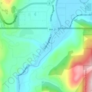
Name: Danville topographic map, elevation, terrain.

Location: Danville, Ferry County, Washington, 99121, United States (48.97240 -118.52808 49.01240 -118.48808)

Average elevation: 2,093 ft

Minimum elevation: 1,713 ft

Maximum elevation: 3,435 ft

Ferry County trails, hiking, mountain biking, running and outdoor activities

Other topographic maps

Click on a map to view its topography, its elevation and its terrain.

Inchelium

United States > Washington > Ferry County

Average elevation: 2,096 ft

Keller

United States > Washington > Ferry County > Keller

Average elevation: 2,218 ft

Ferry Lake

United States > Washington > Ferry County

Average elevation: 3,432 ft

Wiseman Island

United States > Washington > Ferry County > Pollard

Average elevation: 2,549 ft

Gear up for your next adventure:

🪓Survival Multi‑Tool - Versatile tool for camp and trail tasks
🪑Portable Camp Table - Compact table for campsite meals
🧤Hiking Gloves - Protective gloves for rugged trails
🌲Outdoor Survival Books - Best books on survival skills
🕶️Glacier Sunglasses - Side shields to protect eyes from high-altitude snow glare

As an Amazon Associate, this site earns from qualifying purchases at no extra cost to you.