Geolocate

Inchelium topographic map

Click on the map to display elevation.

About this map

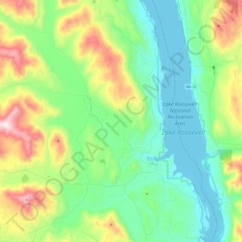
Name: Inchelium topographic map, elevation, terrain.

Location: Inchelium, Ferry County, Washington, United States (48.25165 -118.29658 48.40638 -118.18833)

Average elevation: 2,096 ft

Minimum elevation: 1,260 ft

Maximum elevation: 4,091 ft

Ferry County trails, hiking, mountain biking, running and outdoor activities

Other topographic maps

Click on a map to view its topography, its elevation and its terrain.

Orient

United States > Washington > Ferry County

Average elevation: 1,962 ft

Keller

United States > Washington > Ferry County

Average elevation: 1,759 ft

Laurier

United States > Washington > Ferry County

Average elevation: 1,982 ft

Malo

United States > Washington > Ferry County

Average elevation: 2,585 ft

Danville

United States > Washington > Ferry County

Average elevation: 2,093 ft

Curlew

United States > Washington > Ferry County

Curlew is located at the confluence of Long Alec Creek and the Kettle River. Its elevation is 1,800 feet (550 m) above sea level. Via State Route 21, it is 21 miles (34 km) north of Republic, the Ferry County seat, and 10 miles (16 km) south of the Canadian border.

Average elevation: 2,205 ft

Ferry Lake

United States > Washington > Ferry County

Average elevation: 3,432 ft

Wiseman Island

United States > Washington > Ferry County > Pollard

Average elevation: 2,549 ft

Gear up for your next adventure:

🥾Men's Hiking Boots - Durable, waterproof footwear for rugged terrain and steep inclines
📡GPS Antenna Upgrade - Enhance GPS reception in remote terrain
🌎3D Topographic Globes - Raised relief globes for a tactile understanding of geography
🎒Trekking Poles - Sturdy poles for balance and stability on rough terrain
☀️Outdoor Sunscreen - High protection sunscreen for outdoor activities

As an Amazon Associate, this site earns from qualifying purchases at no extra cost to you.