Geolocate

La Russell topographic map

Click on the map to display elevation.

About this map

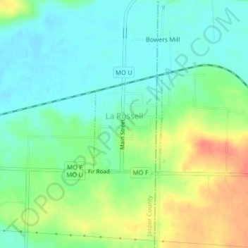
Name: La Russell topographic map, elevation, terrain.

Location: La Russell, Jasper County, Missouri, United States (37.13522 -94.06583 37.14595 -94.05643)

Average elevation: 1,079 ft

Minimum elevation: 1,017 ft

Maximum elevation: 1,184 ft

Jasper County trails, hiking, mountain biking, running and outdoor activities

Other topographic maps

Click on a map to view its topography, its elevation and its terrain.

Atlas

United States > Missouri > Jasper County

Average elevation: 1,037 ft

Oakland Park

United States > Missouri > Jasper County > Webb City

Average elevation: 1,020 ft

Belle Center

United States > Missouri > Jasper County

Average elevation: 961 ft

Joplin

United States > Missouri > Jasper County > Joplin

Average elevation: 984 ft

Center Creek

United States > Missouri > Jasper County > Oronogo

Average elevation: 981 ft

Gear up for your next adventure:

🛠️Backpacking Tool Kit - Essential toolkit for outdoor repairs
😴Insulated Sleeping Pads - Compact and warm pads for high-elevation camping
📶Satellite Messenger - Communication device off‑grid
📡Handheld GPS Device - Reliable handheld GPS for outdoor navigation
🛌Ultralight Sleeping Bags - Compact down bags for cold nights in the wilderness

As an Amazon Associate, this site earns from qualifying purchases at no extra cost to you.