Geolocate

Carterville topographic map

Click on the map to display elevation.

About this map

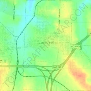
Name: Carterville topographic map, elevation, terrain.

Location: Carterville, Jasper County, Missouri, 64835, United States (37.13386 -94.45203 37.16276 -94.42042)

Average elevation: 988 ft

Minimum elevation: 919 ft

Maximum elevation: 1,070 ft

Jasper County trails, hiking, mountain biking, running and outdoor activities

Other topographic maps

Click on a map to view its topography, its elevation and its terrain.

Atlas

United States > Missouri > Jasper County

Average elevation: 1,037 ft

Oakland Park

United States > Missouri > Jasper County > Webb City

Average elevation: 1,020 ft

Joplin

United States > Missouri > Jasper County > Joplin

Average elevation: 984 ft

Belle Center

United States > Missouri > Jasper County

Average elevation: 961 ft

Center Creek

United States > Missouri > Jasper County > Oronogo

Average elevation: 981 ft

Gear up for your next adventure:

📷Action Cameras - Rugged cameras to document your journeys across rugged terrain
🎒Trail Energy Bars - High‑calorie bars for hiking energy
📡GPS Antenna Upgrade - Enhance GPS reception in remote terrain
📌Outdoor GPS Map App - Apps and devices for digital topographic navigation
🧦Hiking Socks - Comfortable socks to prevent blisters on long hikes

As an Amazon Associate, this site earns from qualifying purchases at no extra cost to you.