
Saint Paul topographic map
Click on the map to display elevation.
Saint Paul
St. Paul is located in the Upper Boston Mountains ecoregion. The ecoregion is generally higher and moister than the Lower Boston Mountains; elevations vary from 1,900 to 2,800 feet (580 to 850 m). Potential natural vegetation is oak–hickory forest. Characteristically, the forests of the Upper Boston Mountains are more closed and contain far less pine than those of the Lower Boston Mountains. North-facing slopes support mesic forests. The region is underlain by Pennsylvanian sandstone, shale and siltstone that contrasts with the limestone and dolomite that dominates the Ozark Highlands. Water quality in streams reflects geology, soils, and land use, and is typically exceptional; mineral, nutrient, and solid concentrations as well as turbidity all tend to be very low. During the summer, many streams do not flow. The timber industry was once a source of many jobs.
About this map
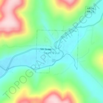
Name: Saint Paul topographic map, elevation, terrain.
Location: Saint Paul, Madison County, Arkansas, 72760, United States (35.81788 -93.77041 35.82917 -93.75661)
Average elevation: 1,736 ft
Minimum elevation: 1,457 ft
Maximum elevation: 2,297 ft
Madison County trails, hiking, mountain biking, running and outdoor activities
Other topographic maps
Click on a map to view its topography, its elevation and its terrain.