
Make a donation
Gear up for your next adventure:
As an Amazon Associate, this site earns from qualifying purchases at no extra cost to you.
General Simón Bolívar topographic map
Click on the map to display elevation.
Make a donation
Gear up for your next adventure:
As an Amazon Associate, this site earns from qualifying purchases at no extra cost to you.
About this map
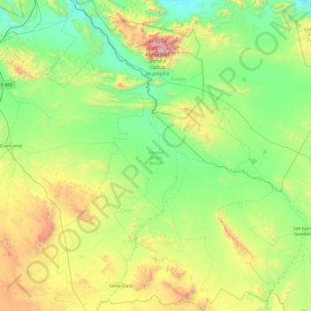
Name: General Simón Bolívar topographic map, elevation, terrain.
Location: General Simón Bolívar, Durango, Mexico (24.40163 -103.58950 25.27871 -102.87784)
Average elevation: 5,420 ft
Minimum elevation: 3,783 ft
Maximum elevation: 10,236 ft
Make a donation
Gear up for your next adventure:
As an Amazon Associate, this site earns from qualifying purchases at no extra cost to you.
Other topographic maps
Click on a map to view its topography, its elevation and its terrain.
Make a donation
Gear up for your next adventure:
As an Amazon Associate, this site earns from qualifying purchases at no extra cost to you.
Cienega de Nuestra Señora
Mexico > Durango > Santiago Papasquiaro > Cienega de Nuestra Señora
Average elevation: 8,501 ft
Make a donation
Gear up for your next adventure:
As an Amazon Associate, this site earns from qualifying purchases at no extra cost to you.