Geolocate

Oak topographic map

Click on the map to display elevation.

About this map

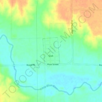
Name: Oak topographic map, elevation, terrain.

Location: Oak, Nuckolls County, Nebraska, 68964, United States (40.23455 -97.90624 40.24179 -97.90035)

Average elevation: 1,611 ft

Minimum elevation: 1,562 ft

Maximum elevation: 1,680 ft

Nuckolls County trails, hiking, mountain biking, running and outdoor activities

Other topographic maps

Click on a map to view its topography, its elevation and its terrain.

Bostwick

United States > Nebraska > Nuckolls County

Average elevation: 1,627 ft

Gear up for your next adventure:

🛰️Satellite Messengers - Emergency SOS and two-way messaging for off-grid adventures
📶Satellite Messenger - Communication device off‑grid
🧭Map Reading Tools - Tools and kits for map navigation
🥾Women's Hiking Boots - Top-rated trail boots with ankle support and superior grip
🪵Folding Camp Saw - Compact saw for wood and campsite work

As an Amazon Associate, this site earns from qualifying purchases at no extra cost to you.