
Make a donation
Gear up for your next adventure:
As an Amazon Associate, this site earns from qualifying purchases at no extra cost to you.
Castle Dale topographic map
Click on the map to display elevation.
Make a donation
Gear up for your next adventure:
As an Amazon Associate, this site earns from qualifying purchases at no extra cost to you.
About this map
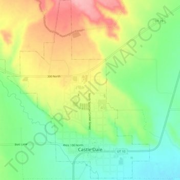
Name: Castle Dale topographic map, elevation, terrain.
Location: Castle Dale, Emery County, Utah, 84513, United States (39.20557 -111.04270 39.24431 -111.00308)
Average elevation: 5,768 ft
Minimum elevation: 5,587 ft
Maximum elevation: 6,004 ft
Emery County trails, hiking, mountain biking, running and outdoor activities
Make a donation
Gear up for your next adventure:
As an Amazon Associate, this site earns from qualifying purchases at no extra cost to you.
Other topographic maps
Click on a map to view its topography, its elevation and its terrain.
Make a donation
Gear up for your next adventure:
As an Amazon Associate, this site earns from qualifying purchases at no extra cost to you.
Castle Dale
United States > Utah > Emery County > Castle Dale > Castle Dale
Average elevation: 5,725 ft