
Make a donation
Gear up for your next adventure:
As an Amazon Associate, this site earns from qualifying purchases at no extra cost to you.
Joes Valley Reservoir topographic map
Click on the map to display elevation.
Make a donation
Gear up for your next adventure:
As an Amazon Associate, this site earns from qualifying purchases at no extra cost to you.
About this map
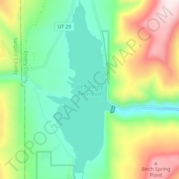
Name: Joes Valley Reservoir topographic map, elevation, terrain.
Location: Joes Valley Reservoir, Emery County, Utah, United States (39.26992 -111.29232 39.31719 -111.26994)
Average elevation: 7,487 ft
Minimum elevation: 6,765 ft
Maximum elevation: 8,898 ft
Emery County trails, hiking, mountain biking, running and outdoor activities
Make a donation
Gear up for your next adventure:
As an Amazon Associate, this site earns from qualifying purchases at no extra cost to you.
Other topographic maps
Click on a map to view its topography, its elevation and its terrain.
Make a donation
Gear up for your next adventure:
As an Amazon Associate, this site earns from qualifying purchases at no extra cost to you.
Castle Dale
United States > Utah > Emery County > Castle Dale > Castle Dale
Average elevation: 5,725 ft