
Make a donation
Gear up for your next adventure:
As an Amazon Associate, this site earns from qualifying purchases at no extra cost to you.
Marilleva topographic map
Click on the map to display elevation.
Make a donation
Gear up for your next adventure:
As an Amazon Associate, this site earns from qualifying purchases at no extra cost to you.
About this map
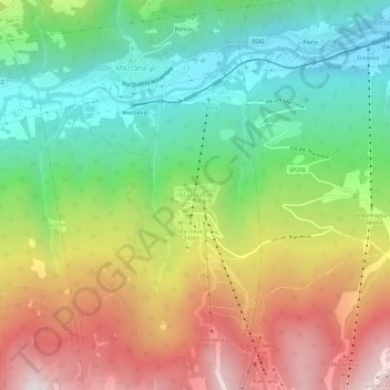
Name: Marilleva topographic map, elevation, terrain.
Average elevation: 4,455 ft
Minimum elevation: 2,651 ft
Maximum elevation: 6,969 ft
Make a donation
Gear up for your next adventure:
As an Amazon Associate, this site earns from qualifying purchases at no extra cost to you.
Other topographic maps
Click on a map to view its topography, its elevation and its terrain.
Trento
Italy > Trentino – Alto Adige/Südtirol > Provincia di Trento
The municipality of Trento stretches across a wide range of altitude levels, going from just under 200 m above sea level at the city centre, to 400 m in Povo and Cognola, to 2000 m above sea level at Monte Bondone, boroughs at higher elevation, for instance Viote, have a colder alpine climate (Dw). Urban…
Average elevation: 2,589 ft
Riva del Garda
Italy > Trentino – Alto Adige/Südtirol > Provincia di Trento
Average elevation: 2,060 ft
Fiera di Primiero
Italy > Trentino – Alto Adige/Südtirol > Provincia di Trento
Average elevation: 2,881 ft
Make a donation
Gear up for your next adventure:
As an Amazon Associate, this site earns from qualifying purchases at no extra cost to you.
Trento
Italy > Trentino – Alto Adige/Südtirol > Provincia di Trento
The municipality of Trento stretches across a wide range of altitude levels, going from just under 200 m above sea level at the city centre, to 400 m in Povo and Cognola, to 2000 m above sea level at Monte Bondone, boroughs at higher elevation, for instance Viote, have a colder alpine climate (Dw). Urban…
Average elevation: 2,589 ft
Val di Fiemme
Italy > Trentino – Alto Adige/Südtirol > Provincia di Trento > Panchià
Average elevation: 5,381 ft
Make a donation
Gear up for your next adventure:
As an Amazon Associate, this site earns from qualifying purchases at no extra cost to you.
Make a donation
Gear up for your next adventure:
As an Amazon Associate, this site earns from qualifying purchases at no extra cost to you.
Make a donation
Gear up for your next adventure:
As an Amazon Associate, this site earns from qualifying purchases at no extra cost to you.
Castello Tesino
Italy > Trentino – Alto Adige/Südtirol > Provincia di Trento
Average elevation: 4,429 ft
Make a donation
Gear up for your next adventure:
As an Amazon Associate, this site earns from qualifying purchases at no extra cost to you.
Lago di Molveno
Italy > Trentino – Alto Adige/Südtirol > Provincia di Trento > Molveno
Average elevation: 3,514 ft
Levico Terme
Italy > Trentino – Alto Adige/Südtirol > Provincia di Trento
The town is dominated by the mountains of the Lagorai range on the north, with Monte Fronte, elevation 1,582 metres (5,190 ft), and Monte Panarotta (2,002 metres (6,568 ft)), and the zone of the Plateaus (Vezzena, Lavarone, Luserna, Folgaria) on the south, where Cima Vezzena, also locally called Pizzo di…
Average elevation: 3,123 ft
Make a donation
Gear up for your next adventure:
As an Amazon Associate, this site earns from qualifying purchases at no extra cost to you.
Make a donation
Gear up for your next adventure:
As an Amazon Associate, this site earns from qualifying purchases at no extra cost to you.
Sella group
Italy > Trentino – Alto Adige/Südtirol > Provincia di Trento > Canazei
Average elevation: 6,955 ft
Borgo Valsugana
Italy > Trentino – Alto Adige/Südtirol > Provincia di Trento
Average elevation: 3,550 ft
Make a donation
Gear up for your next adventure:
As an Amazon Associate, this site earns from qualifying purchases at no extra cost to you.
Fiera di Primiero
Italy > Trentino – Alto Adige/Südtirol > Provincia di Trento
Average elevation: 2,881 ft
Make a donation
Gear up for your next adventure:
As an Amazon Associate, this site earns from qualifying purchases at no extra cost to you.
Valsorda
Italy > Trentino – Alto Adige/Südtirol > Provincia di Trento > Predazzo
Average elevation: 5,856 ft
Ville d'Anaunia
Italy > Trentino – Alto Adige/Südtirol > Provincia di Trento
Average elevation: 4,780 ft
San Martino di Castrozza
Italy > Trentino – Alto Adige/Südtirol > Provincia di Trento
Average elevation: 6,578 ft
Make a donation
Gear up for your next adventure:
As an Amazon Associate, this site earns from qualifying purchases at no extra cost to you.
Lago di Lagolo
Italy > Trentino – Alto Adige/Südtirol > Provincia di Trento > Lagolo
Average elevation: 3,294 ft
Make a donation
Gear up for your next adventure:
As an Amazon Associate, this site earns from qualifying purchases at no extra cost to you.
Canal San Bovo
Italy > Trentino – Alto Adige/Südtirol > Provincia di Trento
Average elevation: 5,075 ft
Make a donation
Gear up for your next adventure:
As an Amazon Associate, this site earns from qualifying purchases at no extra cost to you.
valle dell'Anza
Italy > Trentino – Alto Adige/Südtirol > Provincia di Trento > Levico Terme > Selva di Levico > Masi Rossi
Average elevation: 2,648 ft
Make a donation
Gear up for your next adventure:
As an Amazon Associate, this site earns from qualifying purchases at no extra cost to you.
Pinzolo
Italy > Trentino – Alto Adige/Südtirol > Provincia di Trento
Pinzolo (Eastern Lombard: Pinsöl) is a small town and comune situated in Val Rendena in Trentino in the northern Italian Alps at an elevation of 800 metres (2,600 ft). The Church of Saint Vigilius of Trent stands in the town.
Average elevation: 6,312 ft
Trento
Italy > Trentino – Alto Adige/Südtirol > Provincia di Trento
The municipality of Trento stretches across a wide range of altitude levels, going from just under 200 m above sea level at the city centre, to 400 m in Povo and Cognola, to 2000 m above sea level at Monte Bondone, boroughs at higher elevation, for instance Viote, have a colder alpine climate (Dw). Urban…
Average elevation: 2,589 ft
Make a donation
Gear up for your next adventure:
As an Amazon Associate, this site earns from qualifying purchases at no extra cost to you.
Riva del Garda
Italy > Trentino – Alto Adige/Südtirol > Provincia di Trento
Average elevation: 2,060 ft