
Ala topographic map
Click on the map to display elevation.
About this map
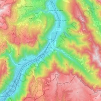
Name: Ala topographic map, elevation, terrain.
Average elevation: 3,104 ft
Minimum elevation: 384 ft
Maximum elevation: 6,493 ft
Other topographic maps
Click on a map to view its topography, its elevation and its terrain.
Trento
Italy > Trentino-Alto Adige/Südtirol > Provincia di Trento > Trento
Trento has a humid subtropical-continental climate (Cfa-Dfa) through most of its populated areas according to the Köppen climate classification. Boroughs at higher elevation like Viote have a colder alpine climate (Dw). Monthly average temperatures range between 1.6 °C (January) and 23.4 °C (July). Annual…
Average elevation: 3,182 ft
Val di Non
Italy > Trentino-Alto Adige/Südtirol > Provincia di Trento > Ville d'Anaunia
Average elevation: 3,245 ft
Castel Beseno
Italy > Trentino-Alto Adige/Südtirol > Provincia di Trento > Besenello > Sottocastello
Average elevation: 1,276 ft
Passo Fedaia
Italy > Trentino-Alto Adige/Südtirol > Provincia di Trento > Canazei
Average elevation: 7,379 ft
Jouf de Pordoi - Passo Pordoi - Pordoijoch
Italy > Trentino-Alto Adige/Südtirol > Provincia di Trento > Canazei
Average elevation: 7,490 ft
Nanno
Italy > Trentino-Alto Adige/Südtirol > Provincia di Trento > Ville d'Anaunia
Average elevation: 1,752 ft
Cascata della Valletta Alta
Italy > Trentino-Alto Adige/Südtirol > Provincia di Trento
Average elevation: 7,539 ft
Riva del Garda
Italy > Trentino-Alto Adige/Südtirol > Provincia di Trento > Riva del Garda
Average elevation: 1,591 ft
Romallo
Italy > Trentino-Alto Adige/Südtirol > Provincia di Trento > Novella
Average elevation: 2,572 ft
Roncafort
Italy > Trentino-Alto Adige/Südtirol > Provincia di Trento > Trento
Average elevation: 1,119 ft
Piani de Porcil
Italy > Trentino-Alto Adige/Südtirol > Provincia di Trento > Vallelaghi
Average elevation: 3,681 ft
Cembra
Italy > Trentino-Alto Adige/Südtirol > Provincia di Trento > Cembra
Average elevation: 2,516 ft
Fucine
Italy > Trentino-Alto Adige/Südtirol > Provincia di Trento > Ossana > Fucine
Average elevation: 4,357 ft