
泰前街道 topographic map
Interactive map
Click on the map to display elevation.
About this map
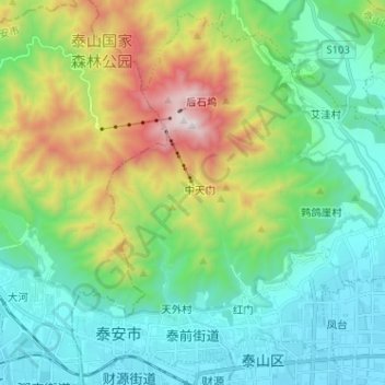
Name: 泰前街道 topographic map, elevation, terrain.
Location: 泰前街道, 泰山区, 泰安市, 山东省, 271000, 中国 (36.18861 117.06537 36.28657 117.19330)
Average elevation: 1,683 ft
Minimum elevation: 433 ft
Maximum elevation: 5,016 ft
Other topographic maps
Click on a map to view its topography, its elevation and its terrain.