
Pescadero topographic map
Click on the map to display elevation.
About this map
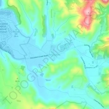
Name: Pescadero topographic map, elevation, terrain.
Average elevation: 144 ft
Minimum elevation: -7 ft
Maximum elevation: 623 ft
San Mateo County trails, hiking, mountain biking, running and outdoor activities
Other topographic maps
Click on a map to view its topography, its elevation and its terrain.
Coyote Point Recreation Area
United States > California > San Mateo County > San Mateo
Average elevation: 3 ft
Sky Londa
United States > California > San Mateo County
Atop the coastal range west of Woodside, the community's official elevation is 1,520 feet (463 m) above mean sea level (AMSL).
Average elevation: 1,437 ft
Upper Crystal Springs Reservoir
United States > California > San Mateo County
Average elevation: 394 ft