Geolocate

Makanya topographic map

Click on the map to display elevation.

About this map

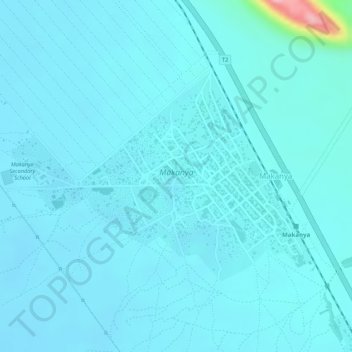
Name: Makanya topographic map, elevation, terrain.

Location: Makanya, Same, Kilimanjaro, Northern Zone, Tanzania (-4.36814 37.80667 -4.35205 37.82995)

Average elevation: 2,221 ft

Minimum elevation: 2,165 ft

Maximum elevation: 2,756 ft

Other topographic maps

Click on a map to view its topography, its elevation and its terrain.

Uhuru Peak

Tanzania > Kilimanjaro

Average elevation: 18,025 ft

Pasua

Tanzania > Kilimanjaro

Average elevation: 2,595 ft

Kilimanjaro National Park

Tanzania > Kilimanjaro

Average elevation: 7,014 ft

Pasua

Tanzania > Kilimanjaro

Average elevation: 2,595 ft

Pasua

Tanzania > Kilimanjaro

Average elevation: 2,595 ft

Gavao Saweni

Tanzania > Kilimanjaro

Average elevation: 2,313 ft

Njoro

Tanzania > Kilimanjaro

Average elevation: 2,667 ft

Moshi

Tanzania > Kilimanjaro

Moshi's lower altitude and drier climate mean that the main crops grown on the higher slopes of Mt Kilimanjaro, coffee and bananas, do not thrive there. The surrounding areas in Moshi district are known for extensive farms of maize and beans, grown once per year during the long rainy season (known as "masika"…

Average elevation: 3,638 ft

Kinondo

Tanzania > Kilimanjaro

Average elevation: 3,392 ft

Soweto

Tanzania > Kilimanjaro

Average elevation: 2,841 ft

Marangu

Tanzania > Kilimanjaro

Average elevation: 4,846 ft

Hedaru

Tanzania > Kilimanjaro

Average elevation: 2,297 ft

Moshi

Tanzania > Kilimanjaro

Moshi's lower altitude and dry climate mean that the main crops grown on the higher slopes of Mount Kilimanjaro, coffee and bananas, do not thrive there. The surrounding areas in Moshi district are known for extensive farms of maize and beans, grown once per year during the long rainy season (known as "masika"…

Average elevation: 3,638 ft

Boma Mbuzi

Tanzania > Kilimanjaro

Average elevation: 2,598 ft

Maua

Tanzania > Kilimanjaro

Average elevation: 4,777 ft

Pasua

Tanzania > Kilimanjaro

Average elevation: 2,595 ft

Msae Nganyeni

Tanzania > Kilimanjaro

Average elevation: 4,908 ft

Moshi Rural

Tanzania > Kilimanjaro

Average elevation: 4,042 ft

Soweto

Tanzania > Kilimanjaro

Average elevation: 2,841 ft

Marangu

Tanzania > Kilimanjaro

Average elevation: 4,252 ft

Mwika

Tanzania > Kilimanjaro

Average elevation: 4,731 ft

Mwanga

Tanzania > Kilimanjaro

Average elevation: 2,766 ft

Same

Tanzania > Kilimanjaro

The city is located in the interior of the island, 49 kilometres (30 mi) south of the provincial capital of Dili, at an altitude of 384 metres (1,260 ft), south of the mountain Cabalaki (Foho Kabulaki). The centre is located in the Suco Letefoho in which are situated the districts Ria-Lau (Rialau) Manico 1, 2…

Average elevation: 3,248 ft

Nshara

Tanzania > Kilimanjaro

Average elevation: 3,655 ft

Moshi

Tanzania > Kilimanjaro

Moshi's lower altitude and drier climate mean that the main crops grown on the higher slopes of Mt Kilimanjaro, coffee and bananas, do not thrive there. The surrounding areas in Moshi district are known for extensive farms of maize and beans, grown once per year during the long rainy season (known as "masika"…

Average elevation: 3,638 ft

Kibolironi Ward

Tanzania > Kilimanjaro > Kibolironi Ward

Average elevation: 2,851 ft

Pasua

Tanzania > Kilimanjaro

Average elevation: 2,595 ft

Uduru

Tanzania > Kilimanjaro

Average elevation: 4,203 ft

Mkoringa

Tanzania > Kilimanjaro

Average elevation: 4,239 ft

Gear up for your next adventure:

🪶Compact Camp Shovel - Folding shovel for campsite tasks
🧭Hiking Compass - Precision compass for reliable navigation in the wilderness
🎒Day Hiking Backpack - Lightweight backpack perfect for day trips and outdoor adventures
🔋Solar Power Banks - Keep your GPS and phone charged in remote wilderness areas
🪑Ultralight Camp Chairs - Portable seating for resting after a long day of mapping

As an Amazon Associate, this site earns from qualifying purchases at no extra cost to you.