
Moshi topographic map
Click on the map to display elevation.
Moshi
Moshi's lower altitude and drier climate mean that the main crops grown on the higher slopes of Mt Kilimanjaro, coffee and bananas, do not thrive there. The surrounding areas in Moshi district are known for extensive farms of maize and beans, grown once per year during the long rainy season (known as "masika" in Kiswahili). In addition, the Tanganyika Planting Company operates a very large sugar cane plantation and company town 20 kilometres (12 mi) south of Moshi.
About this map
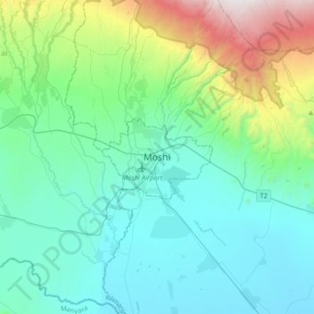
Name: Moshi topographic map, elevation, terrain.
Average elevation: 3,638 ft
Minimum elevation: 2,293 ft
Maximum elevation: 9,167 ft
Other topographic maps
Click on a map to view its topography, its elevation and its terrain.
Kilimanjaro
Mount Kilimanjaro (/ˌkɪlɪmənˈdʒɑːroʊ/) is a dormant volcano in Tanzania. It is the highest mountain in Africa and the highest free-standing mountain above sea level in the world: 5,895 m (19,341 ft) above sea level and 4,900 m (16,100 ft) above its plateau base. It is also the highest volcano in the…
Average elevation: 5,043 ft
Kilimanjaro
The mountain was incorporated into Kilimanjaro National Park in 1973. As one of the Seven Summits, Kilimanjaro is a major hiking and climbing destination. There are seven established routes to Uhuru Peak, the mountain's highest point. Although not as technically challenging as similar mountains, the prominence…
Average elevation: 5,043 ft
Kilimanjaro
Kilimanjaro is the fourth most topographically prominent peak on Earth. It is part of Kilimanjaro National Park and is a major hiking and climbing destination. Because of its shrinking glaciers and ice fields, which are projected to disappear between 2025 and 2035, it has been the subject of many scientific…
Average elevation: 5,043 ft
Kilimanjaro
Mount Kilimanjaro (/ˌkɪlɪmənˈdʒɑːroʊ/) is a dormant volcano in Tanzania. It is the highest mountain in Africa and the highest free-standing mountain above sea level in the world: 5,895 m (19,341 ft) above sea level and 4,900 m (16,100 ft) above its plateau base. It is also the highest volcano in the…
Average elevation: 5,043 ft
Kilimanjaro
Mount Kilimanjaro (/ˌkɪlɪmənˈdʒɑːroʊ/) is a dormant volcano in Tanzania. It is the highest mountain in Africa and the highest free-standing mountain above sea level in the world, situated at 5,895 m (19,341 ft) above sea level and 4,900 m (16,100 ft) above its plateau base. It is also the highest…
Average elevation: 5,043 ft
Kilimanjaro
Mount Kilimanjaro (/ˌkɪlɪmənˈdʒɑːroʊ/) is a dormant volcano in Tanzania. It is the highest mountain in Africa and the highest free-standing mountain above sea level in the world, at 5,895 m (19,341 ft) above sea level and 4,900 m (16,100 ft) above its plateau base. It is also the highest volcano in…
Average elevation: 5,043 ft
Kilimanjaro
Mount Kilimanjaro (/ˌkɪlɪmənˈdʒɑːroʊ/) is a large dormant volcano in Tanzania. It is the highest mountain in Africa and the highest free-standing mountain above sea level in the world, at 5,895 m (19,341 ft) above sea level and 4,900 m (16,100 ft) above its plateau base. It is also the highest volcano…
Average elevation: 5,043 ft
Lake Chala
Lake Chala's average annual rainfall is about 565 millimetres (22.2 in). The lake surface has an average annual evaporation of near 1,735 millimetres (68.3 in). Approximately 80 percent of the lake's inflow comes from groundwater, which is derived mostly from rainfall in the montane forest zone of Mount…
Average elevation: 2,953 ft
Kilimanjaro
Kilimanjaro is the fourth most topographically prominent peak on Earth. It is part of Kilimanjaro National Park and is a major hiking and climbing destination. Because of its shrinking glaciers and ice fields, which are projected to disappear between 2025 and 2035, it has been the subject of many scientific…
Average elevation: 5,043 ft
Kilimanjaro
Mount Kilimanjaro (/ˌkɪlɪmənˈdʒɑːroʊ/) is a dormant volcano in Tanzania. It is the highest mountain in Africa and the highest free-standing mountains above sea level in the world, at 5,895 m (19,341 ft) above sea level and 4,900 m (16,100 ft) above its plateau base. It is also the highest volcano in…
Average elevation: 5,043 ft