Geolocate

Vesuvius topographic map

Click on the map to display elevation.

About this map

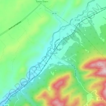
Name: Vesuvius topographic map, elevation, terrain.

Location: Vesuvius, Rockbridge County, Virginia, 24472, United States (37.88624 -79.21725 37.92624 -79.17725)

Average elevation: 1,726 ft

Minimum elevation: 1,302 ft

Maximum elevation: 2,582 ft

Rockbridge County trails, hiking, mountain biking, running and outdoor activities

Other topographic maps

Click on a map to view its topography, its elevation and its terrain.

Goshen

United States > Virginia > Rockbridge County

Average elevation: 1,549 ft

Glasgow

United States > Virginia > Rockbridge County

Average elevation: 932 ft

Hays Creek

United States > Virginia > Rockbridge County

Average elevation: 1,437 ft

Gear up for your next adventure:

📱Heavy-Duty Phone Cases - Drop-proof and waterproof protection for outdoor navigation
🧢Sun Protection Hats - Wide-brimmed and UPF-rated hats for high-altitude sun safety
🗺️Topographic Maps - Detailed topo maps for hiking, exploring and outdoor navigation
🏥Hiking First Aid Kits - Comprehensive medical kits for remote trail injuries
🩹Survival Bandages - High‑quality bandages for emergencies

As an Amazon Associate, this site earns from qualifying purchases at no extra cost to you.