Geolocate

Ciwaruga topographic map

Click on the map to display elevation.

About this map

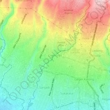
Name: Ciwaruga topographic map, elevation, terrain.

Location: Ciwaruga, Bandung, West Java, Java, 40559, Indonesia (-6.88138 107.56171 -6.84138 107.60171)

Average elevation: 2,930 ft

Minimum elevation: 2,530 ft

Maximum elevation: 3,510 ft

Other topographic maps

Click on a map to view its topography, its elevation and its terrain.

Sarijadi

Indonesia > West Java > Bandung

Average elevation: 2,694 ft

Gegerkalong

Indonesia > West Java > Bandung

Average elevation: 2,818 ft

Cijerah

Indonesia > West Java > Bandung

Average elevation: 2,333 ft

Sukamaju

Indonesia > West Java > Bandung

Average elevation: 2,303 ft

Isola

Indonesia > West Java > Bandung

Average elevation: 3,199 ft

Citarum

Indonesia > West Java > Bandung

Average elevation: 2,382 ft

Sukaraja

Indonesia > West Java > Bandung > Sukaraja

Average elevation: 2,470 ft

Gear up for your next adventure:

🪑Ultralight Camp Chairs - Portable seating for resting after a long day of mapping
🪶Compact Camp Shovel - Folding shovel for campsite tasks
🏥Hiking First Aid Kits - Comprehensive medical kits for remote trail injuries
🛌Ultralight Sleeping Bags - Compact down bags for cold nights in the wilderness
👓Polarized Sunglasses - Outdoor sunglasses for glare reduction

As an Amazon Associate, this site earns from qualifying purchases at no extra cost to you.