Geolocate

Evans topographic map

Click on the map to display elevation.

About this map

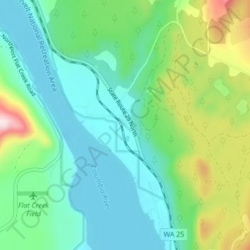
Name: Evans topographic map, elevation, terrain.

Location: Evans, Stevens County, Washington, 99126, United States (48.69352 -118.04527 48.73352 -118.00527)

Average elevation: 1,598 ft

Minimum elevation: 1,253 ft

Maximum elevation: 2,569 ft

Stevens County trails, hiking, mountain biking, running and outdoor activities

Other topographic maps

Click on a map to view its topography, its elevation and its terrain.

Lake Roosevelt

United States > Washington > Stevens County

Average elevation: 2,963 ft

Gear up for your next adventure:

🛏️Cold Weather Sleeping Bag - Warm sleeping bag for cold conditions
GPS Sports Watch - GPS watch for running, hiking and training
🧦Merino Wool Socks - Moisture-wicking, blister-preventing socks for long treks
🩹Survival Bandages - High‑quality bandages for emergencies
🥾Men's Hiking Boots - Durable, waterproof footwear for rugged terrain and steep inclines

As an Amazon Associate, this site earns from qualifying purchases at no extra cost to you.