
Make a donation
Gear up for your next adventure:
As an Amazon Associate, this site earns from qualifying purchases at no extra cost to you.
Lake Roosevelt topographic map
Click on the map to display elevation.
Make a donation
Gear up for your next adventure:
As an Amazon Associate, this site earns from qualifying purchases at no extra cost to you.
About this map
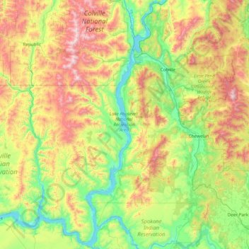
Name: Lake Roosevelt topographic map, elevation, terrain.
Location: Lake Roosevelt, Stevens County, Washington, United States (47.81285 -118.99057 48.82592 -117.92095)
Average elevation: 2,963 ft
Minimum elevation: 1,250 ft
Maximum elevation: 7,106 ft
Stevens County trails, hiking, mountain biking, running and outdoor activities
Make a donation
Gear up for your next adventure:
As an Amazon Associate, this site earns from qualifying purchases at no extra cost to you.
Other topographic maps
Click on a map to view its topography, its elevation and its terrain.
Colville
United States > Washington > Stevens County > Colville > Colville
Average elevation: 1,975 ft
Make a donation
Gear up for your next adventure:
As an Amazon Associate, this site earns from qualifying purchases at no extra cost to you.
Ford
United States > Washington > Stevens County
Ford is located in a mountainous area at the base of Happy Hill, which rises more than 600 feet immediately to the southeast of the community. The northeast–southwest trending Walkers Prairie and valley floor along which Chamokane Creek flows is relatively flat and at an elevation of between 1,700 and 1,800…
Average elevation: 1,893 ft
Make a donation
Gear up for your next adventure:
As an Amazon Associate, this site earns from qualifying purchases at no extra cost to you.
Chewelah
United States > Washington > Stevens County > Chewelah > Chewelah
Average elevation: 2,005 ft