
St Vigeans topographic map
Click on the map to display elevation.
About this map
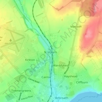
Name: St Vigeans topographic map, elevation, terrain.
Location: St Vigeans, Angus, Scotland, DD11 4RD, United Kingdom (56.55667 -2.60950 56.59667 -2.56950)
Average elevation: 131 ft
Minimum elevation: 0 ft
Maximum elevation: 322 ft
Other topographic maps
Click on a map to view its topography, its elevation and its terrain.