Geolocate

Forfar topographic map

Click on the map to display elevation.

About this map

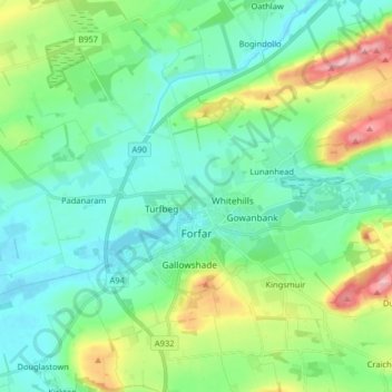
Name: Forfar topographic map, elevation, terrain.

Location: Forfar, Angus, Scotland, United Kingdom (56.60820 -2.96020 56.69719 -2.80990)

Average elevation: 312 ft

Minimum elevation: 167 ft

Maximum elevation: 745 ft

Other topographic maps

Click on a map to view its topography, its elevation and its terrain.

Edzell

United Kingdom > Scotland > Angus

Average elevation: 226 ft

Brechin

United Kingdom > Scotland > Angus

Average elevation: 233 ft

Arbroath

United Kingdom > Scotland > Angus

Average elevation: 79 ft

Kirriemuir

United Kingdom > Scotland > Angus

The family estate of Sir Hugh Munro, who created Munro's Tables of Scottish mountains over 3,000 ft. in elevation (which are now called "munros"), is also located near the town.

Average elevation: 404 ft

Montrose

United Kingdom > Scotland > Angus

Montrose occupies a position on the North Bank of Montrose Basin at the mouth of the River South Esk on the East Coast of Scotland, 11 miles (18 km) NNE of Arbroath, 19 miles (31 km) SW of Stonehaven, and 7.2 miles (12 km) ESE of Brechin. The town lies 62.2 miles (100 km) NNE of Edinburgh, and 373.2 miles (601…

Average elevation: 72 ft

Glen Lethnot

United Kingdom > Scotland > Angus

Average elevation: 1,198 ft

Loch Brandy

United Kingdom > Scotland > Angus

Average elevation: 2,267 ft

Driesh

United Kingdom > Scotland > Angus

Average elevation: 2,313 ft

Newtyle

United Kingdom > Scotland > Angus

Average elevation: 427 ft

Airlie

United Kingdom > Scotland > Angus

Average elevation: 299 ft

Cairn Broadlands

United Kingdom > Scotland > Angus

Average elevation: 1,765 ft

Greystone

United Kingdom > Scotland > Angus

Average elevation: 531 ft

Flocklones

United Kingdom > Scotland > Angus

Average elevation: 226 ft

North Water Bridge

United Kingdom > Scotland > Angus

Average elevation: 167 ft

Piperdam

United Kingdom > Scotland > Angus

Average elevation: 587 ft

Backmuir of Liff

United Kingdom > Scotland > Angus > Muirhead

Average elevation: 417 ft

Oathlaw

United Kingdom > Scotland > Angus

Average elevation: 272 ft

Greenlawhill

United Kingdom > Scotland > Angus > Barry

Average elevation: 79 ft

Glenprosen Lodge

United Kingdom > Scotland > Angus

Average elevation: 1,348 ft

Bridge of Craigisla

United Kingdom > Scotland > Angus

Average elevation: 696 ft

Craigowl Hill

United Kingdom > Scotland > Angus

Average elevation: 958 ft

Brigton

United Kingdom > Scotland > Angus > Ruthven

Average elevation: 220 ft

Mains of Ardestie

United Kingdom > Scotland > Angus > Monifieth

Average elevation: 131 ft

Carlungie

United Kingdom > Scotland > Angus

Average elevation: 217 ft

Tigerton

United Kingdom > Scotland > Angus

Average elevation: 482 ft

Inverkeilor

United Kingdom > Scotland > Angus

Average elevation: 131 ft

Bridge of Dun

United Kingdom > Scotland > Angus

Average elevation: 72 ft

Guthrie

United Kingdom > Scotland > Angus

Average elevation: 249 ft

Glas Maol

United Kingdom > Scotland > Angus

Average elevation: 2,854 ft

Langley Park

United Kingdom > Scotland > Angus

Average elevation: 138 ft

Inchbare

United Kingdom > Scotland > Angus

Average elevation: 184 ft

Ashludie Farm

United Kingdom > Scotland > Angus > Monifieth

Average elevation: 95 ft

Barry

United Kingdom > Scotland > Angus

Average elevation: 72 ft

Aberlemno

United Kingdom > Scotland > Angus

Average elevation: 374 ft

Justinhaugh

United Kingdom > Scotland > Angus > Oathlaw

Average elevation: 282 ft

Padanaram

United Kingdom > Scotland > Angus > Forfar

Average elevation: 223 ft

Bankhead of Kirkbuddo

United Kingdom > Scotland > Angus

Average elevation: 522 ft

Tarfside

United Kingdom > Scotland > Angus

Average elevation: 876 ft

Letham

United Kingdom > Scotland > Angus

Average elevation: 367 ft

Powis

United Kingdom > Scotland > Angus > Barnhead

Average elevation: 92 ft

Auchterhouse

United Kingdom > Scotland > Angus

Average elevation: 558 ft

Sand Martins

United Kingdom > Scotland > Angus > Forfar

Average elevation: 318 ft

North Whitehills

United Kingdom > Scotland > Angus > Forfar

Average elevation: 269 ft

East Haven

United Kingdom > Scotland > Angus

Average elevation: 49 ft

Gallowfauld

United Kingdom > Scotland > Angus

Average elevation: 525 ft

Glen Dye

United Kingdom > Scotland > Angus

Average elevation: 1,365 ft

Carrot Hill

United Kingdom > Scotland > Angus

Average elevation: 630 ft

Monikie

United Kingdom > Scotland > Angus

Average elevation: 486 ft

Kellas

United Kingdom > Scotland > Angus

Average elevation: 312 ft

Berryhill

United Kingdom > Scotland > Angus > Fowlis Easter

Average elevation: 377 ft

Milton of Ogilvie

United Kingdom > Scotland > Angus

Average elevation: 653 ft

Orchard Grove

United Kingdom > Scotland > Angus > St Vigeans

Average elevation: 141 ft

Forter Castle

United Kingdom > Scotland > Angus > Folda

Average elevation: 1,270 ft

Jericho

United Kingdom > Scotland > Angus > Douglastown

Average elevation: 315 ft

Cairn of Claise

United Kingdom > Scotland > Angus

It has an elevation of 1,063.1 m (3,488 ft) and a prominence of 118.9 m (390 ft) and is a Munro.

Average elevation: 3,015 ft

Tolmount

United Kingdom > Scotland > Angus

Average elevation: 2,776 ft

St Vigeans

United Kingdom > Scotland > Angus

Average elevation: 131 ft

Kirriemuir

United Kingdom > Scotland > Angus

The family estate of Sir Hugh Munro, who created Munro's Tables of Scottish mountains over 3,000 feet (914.4 metres) in elevation (which are now called "munros"), is also located near the town.

Average elevation: 404 ft

Deanbank

United Kingdom > Scotland > Angus > Glamis

Average elevation: 272 ft

Inverarity

United Kingdom > Scotland > Angus > Inverarity

Average elevation: 410 ft

Glen Isla

United Kingdom > Scotland > Angus > Kirkton of Glenisla

Average elevation: 1,411 ft

Glen Esk

United Kingdom > Scotland > Angus > Tarfside

Average elevation: 1,079 ft

Colliston

United Kingdom > Scotland > Angus

Average elevation: 220 ft

Craichie

United Kingdom > Scotland > Angus

Average elevation: 397 ft

South Craig

United Kingdom > Scotland > Angus

Average elevation: 2,418 ft

South Ardo

United Kingdom > Scotland > Angus > Brechin > South Ardo

Average elevation: 282 ft

Little Brechin

United Kingdom > Scotland > Angus

Average elevation: 262 ft

Glen Doll

United Kingdom > Scotland > Angus

Average elevation: 2,051 ft

Kirkbuddo

United Kingdom > Scotland > Angus

Average elevation: 522 ft

Woodhill

United Kingdom > Scotland > Angus > Monifieth

Average elevation: 102 ft

Millhouse Cottages

United Kingdom > Scotland > Angus > Tannadice

Average elevation: 302 ft

Wemyss

United Kingdom > Scotland > Angus

Average elevation: 361 ft

Arbroath

United Kingdom > Scotland > Angus

Average elevation: 79 ft

Loch Brandy

United Kingdom > Scotland > Angus

Average elevation: 2,267 ft

Muirhead

United Kingdom > Scotland > Angus

Average elevation: 397 ft

Forter Castle

United Kingdom > Scotland > Angus > Folda

Average elevation: 1,270 ft

Balnamoon

United Kingdom > Scotland > Angus

Average elevation: 377 ft

Elliot

United Kingdom > Scotland > Angus > Arbroath

Average elevation: 56 ft

Greystone

United Kingdom > Scotland > Angus

Average elevation: 531 ft

Muirhead

United Kingdom > Scotland > Angus

Average elevation: 397 ft

Gear up for your next adventure:

🛏️Cold Weather Sleeping Bag - Warm sleeping bag for cold conditions
📡Handheld GPS Device - Reliable handheld GPS for outdoor navigation
🧭GPS Watch Accessories - Bands and chargers for GPS watches
🦺Reflective Outdoor Gear - Safety gear for low‑light conditions
📚Navigation Handbooks - Master the art of reading topographic maps and using a compass

As an Amazon Associate, this site earns from qualifying purchases at no extra cost to you.