
Make a donation
Gear up for your next adventure:
As an Amazon Associate, this site earns from qualifying purchases at no extra cost to you.
Saint Regis Falls topographic map
Click on the map to display elevation.
Make a donation
Gear up for your next adventure:
As an Amazon Associate, this site earns from qualifying purchases at no extra cost to you.
About this map
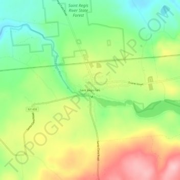
Name: Saint Regis Falls topographic map, elevation, terrain.
Average elevation: 1,280 ft
Minimum elevation: 1,027 ft
Maximum elevation: 1,594 ft
Franklin County trails, hiking, mountain biking, running and outdoor activities
Make a donation
Gear up for your next adventure:
As an Amazon Associate, this site earns from qualifying purchases at no extra cost to you.
Other topographic maps
Click on a map to view its topography, its elevation and its terrain.
Make a donation
Gear up for your next adventure:
As an Amazon Associate, this site earns from qualifying purchases at no extra cost to you.
Make a donation
Gear up for your next adventure:
As an Amazon Associate, this site earns from qualifying purchases at no extra cost to you.
Village of Saranac Lake
United States > New York > Franklin County > Town of Harrietstown
Average elevation: 1,647 ft
Make a donation
Gear up for your next adventure:
As an Amazon Associate, this site earns from qualifying purchases at no extra cost to you.
Fish Creek Pond
United States > New York > Franklin County > Town of Santa Clara
Average elevation: 1,611 ft
Make a donation
Gear up for your next adventure:
As an Amazon Associate, this site earns from qualifying purchases at no extra cost to you.
Village of Saranac Lake
United States > New York > Franklin County > Town of Harrietstown
Average elevation: 1,647 ft
Make a donation
Gear up for your next adventure:
As an Amazon Associate, this site earns from qualifying purchases at no extra cost to you.
Fish Creek Pond Campground
United States > New York > Franklin County > Town of Santa Clara
Average elevation: 1,601 ft
Town of Chateaugay
United States > New York > Franklin County > Town of Chateaugay
Average elevation: 919 ft