
Town of Moira topographic map
Interactive map
Click on the map to display elevation.
About this map
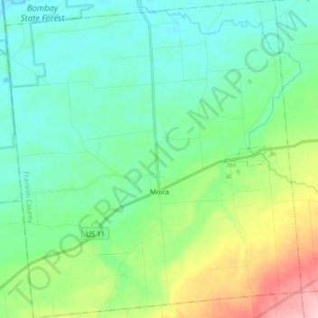
Name: Town of Moira topographic map, elevation, terrain.
Location: Town of Moira, Franklin County, New York, United States (44.77455 -74.63117 44.88415 -74.48676)
Average elevation: 404 ft
Minimum elevation: 253 ft
Maximum elevation: 856 ft
Other topographic maps
Click on a map to view its topography, its elevation and its terrain.
Bay Pond
United States > New York > Franklin County
Bay Pond, Town of Santa Clara, Franklin County, New York, United States
Average elevation: 1,621 ft
Lake Clear
United States > New York > Franklin County
Lake Clear, Town of Harrietstown, Franklin County, New York, 12945, United States
Average elevation: 1,634 ft
St. Regis Falls
United States > New York > Franklin County
St. Regis Falls, Town of Waverly, Franklin County, New York, United States
Average elevation: 1,266 ft
Town of Chateaugay
United States > New York > Franklin County
Town of Chateaugay, Franklin County, New York, 12920, United States
Average elevation: 919 ft
Village of Burke
United States > New York > Franklin County > Town of Burke
Village of Burke, Town of Burke, Franklin County, New York, United States
Average elevation: 863 ft
Village of Brushton
United States > New York > Franklin County
Village of Brushton, Town of Moira, Franklin County, New York, United States
Average elevation: 433 ft
Rainbow Lake
United States > New York > Franklin County
Rainbow Lake, Town of Brighton, Franklin County, New York, 12976, United States
Average elevation: 1,759 ft
Akwesasne
United States > New York > Franklin County > Town of Bombay
Akwesasne, Town of Bombay, Franklin County, New York, United States
Average elevation: 187 ft
North Bangor
United States > New York > Franklin County > Town of Bangor
North Bangor, Town of Bangor, Franklin County, New York, 12966, United States
Average elevation: 669 ft
Hogansburg
United States > New York > Franklin County > Town of Bombay
Hogansburg, Town of Bombay, Franklin County, New York, 13655, United States
Average elevation: 180 ft
South Bombay
United States > New York > Franklin County > Town of Bombay
South Bombay, Town of Bombay, Franklin County, New York, 12957, United States
Average elevation: 272 ft
Gabriels
United States > New York > Franklin County
Gabriels, Town of Brighton, Franklin County, New York, 12939, United States
Average elevation: 1,739 ft
Owls Head
United States > New York > Franklin County
Owls Head, Town of Bellmont, Franklin County, New York, 12969, United States
Average elevation: 1,818 ft
Upper Saint Regis Lake
United States > New York > Franklin County > Town of Harrietstown
Upper Saint Regis Lake, Town of Harrietstown, Town of Brighton, Franklin County, New York, United States
Average elevation: 1,660 ft
Upper Saint Regis
United States > New York > Franklin County > Town of Harrietstown
Upper Saint Regis, Town of Harrietstown, Franklin County, New York, 12945, United States
Average elevation: 1,670 ft
Vermontville
United States > New York > Franklin County
Vermontville, Town of Franklin, Franklin County, New York, 12913, United States
Average elevation: 1,729 ft
Town of Duane
United States > New York > Franklin County
Town of Duane, Franklin County, New York, United States
Average elevation: 1,677 ft
Village of Malone
United States > New York > Franklin County > Town of Malone
Village of Malone, Town of Malone, Franklin County, New York, United States
Average elevation: 768 ft
Town of Bombay
United States > New York > Franklin County
Town of Bombay, Franklin County, New York, United States
Average elevation: 217 ft
Village of Saranac Lake
United States > New York > Franklin County > Town of Harrietstown
Village of Saranac Lake, Town of Harrietstown, Franklin County, New York, United States
Average elevation: 1,647 ft
Town of Fort Covington
United States > New York > Franklin County
Town of Fort Covington, Franklin County, New York, United States
Average elevation: 226 ft
Town of Bangor
United States > New York > Franklin County
Town of Bangor, Franklin County, New York, 12966, United States
Average elevation: 686 ft
Town of Waverly
United States > New York > Franklin County
Town of Waverly, Franklin County, New York, 12980, United States
Average elevation: 1,490 ft
Town of Santa Clara
United States > New York > Franklin County
Town of Santa Clara, Franklin County, New York, United States
Average elevation: 1,568 ft
Paul Smiths
United States > New York > Franklin County
Paul Smiths, Town of Brighton, Franklin County, New York, United States
Average elevation: 1,650 ft
Fish Creek Pond Campground
United States > New York > Franklin County > Santa Clara
Fish Creek Pond Campground, Santa Clara, Franklin County, New York, United States
Average elevation: 1,601 ft
Town of Constable
United States > New York > Franklin County
Town of Constable, Franklin County, New York, 12926, United States
Average elevation: 364 ft
Saginaw Bay
United States > New York > Franklin County > Santa Clara
Saginaw Bay, Santa Clara, Franklin County, New York, United States
Average elevation: 1,654 ft
Lost Mountain
United States > New York > Franklin County
Lost Mountain, Town of Waverly, Franklin County, New York, United States
Average elevation: 1,827 ft
Lake Titus
United States > New York > Franklin County > Town of Malone
Lake Titus, Town of Malone, Franklin County, New York, United States
Average elevation: 1,519 ft
Chasm Falls
United States > New York > Franklin County > Chasm Falls
Chasm Falls, Malone, Franklin County, New York, United States
Average elevation: 1,325 ft
Dickinson Center
United States > New York > Franklin County
Dickinson Center, Town of Dickinson, Franklin County, New York, 12930, United States
Average elevation: 968 ft
Meacham Lake
United States > New York > Franklin County
Meacham Lake, Duane, Franklin County, New York, United States
Average elevation: 1,604 ft
Simon Pond
United States > New York > Franklin County
Simon Pond, Franklin County, New York, United States
Average elevation: 1,647 ft
Harrietstown
United States > New York > Franklin County > Harrietstown
Harrietstown, Franklin County, New York, 12939, United States
Average elevation: 1,680 ft
Osgood Pond
United States > New York > Franklin County > Paul Smiths
Osgood Pond, Paul Smiths, Franklin County, New York, United States
Average elevation: 1,693 ft
Lower Saranac Lake
United States > New York > Franklin County
Lower Saranac Lake, Franklin County, New York, United States
Average elevation: 1,663 ft
Westville Center
United States > New York > Franklin County > Westville Center
Westville Center, Franklin County, New York, United States
Average elevation: 246 ft
Lower Chateaugay Lake
United States > New York > Franklin County > Town of Ellenburg
Lower Chateaugay Lake, Town of Ellenburg, Town of Bellmont, Franklin County, New York, United States
Average elevation: 1,598 ft
Middle Saranac Lake
United States > New York > Franklin County
Middle Saranac Lake, Franklin County, New York, United States
Average elevation: 1,588 ft
Stony Creek
United States > New York > Franklin County
Stony Creek, Franklin County, New York, United States
Average elevation: 1,614 ft
Mountain View Lake
United States > New York > Franklin County > Mountain View
Mountain View Lake, Mountain View, Franklin County, New York, United States
Average elevation: 1,549 ft
Lake Colby
United States > New York > Franklin County > Lake Colby
Lake Colby, Franklin County, New York, 12983, United States
Average elevation: 1,660 ft
Village of Tupper Lake
United States > New York > Franklin County
Village of Tupper Lake, Town of Tupper Lake, Franklin County, New York, 12986, United States
Average elevation: 1,588 ft
Loon Lake
United States > New York > Franklin County > Loon Lake
Loon Lake, Franklin County, New York, United States
Average elevation: 1,696 ft