Geolocate

Brazoria topographic map

Click on the map to display elevation.

About this map

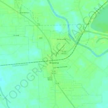
Name: Brazoria topographic map, elevation, terrain.

Location: Brazoria, Brazoria County, Texas, United States (29.02295 -95.59058 29.07415 -95.54307)

Average elevation: 26 ft

Minimum elevation: 3 ft

Maximum elevation: 46 ft

Brazoria County trails, hiking, mountain biking, running and outdoor activities

Other topographic maps

Click on a map to view its topography, its elevation and its terrain.

Clute

United States > Texas > Brazoria County > Clute > Clute

Average elevation: 16 ft

Sandy Point

United States > Texas > Brazoria County

Average elevation: 59 ft

Gear up for your next adventure:

🔪Outdoor Multitools - Essential survival tools for gear repair and field use
🔦LED Headlamp - Bright and durable LED headlamp for night navigation
🧯Emergency Survival Kit - All‑in‑one survival essentials for the backcountry
🔋Solar Power Banks - Keep your GPS and phone charged in remote wilderness areas
Camping Coffee Makers - Enjoy premium coffee at the summit or campsite

As an Amazon Associate, this site earns from qualifying purchases at no extra cost to you.