
Make a donation
Gear up for your next adventure:
As an Amazon Associate, this site earns from qualifying purchases at no extra cost to you.
Oskemen topographic map
Click on the map to display elevation.
Make a donation
Gear up for your next adventure:
As an Amazon Associate, this site earns from qualifying purchases at no extra cost to you.
About this map
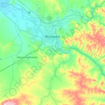
Name: Oskemen topographic map, elevation, terrain.
Location: Oskemen, East Kazakhstan Region, Kazakhstan (49.74028 82.39597 50.04110 82.97388)
Average elevation: 1,404 ft
Minimum elevation: 876 ft
Maximum elevation: 3,212 ft
Make a donation
Gear up for your next adventure:
As an Amazon Associate, this site earns from qualifying purchases at no extra cost to you.
Other topographic maps
Click on a map to view its topography, its elevation and its terrain.
Ridder
Kazakhstan > East Kazakhstan Region
Ridder (Kazakh: Риддер, romanized: Ridder), formerly known as Leninogorsk (Russian: Лениногорск) is a city in the East Kazakhstan Region in north-eastern Kazakhstan. Its population is approximately 50,500 (2009 Census results). The city is situated in the south-western Altai Mountains and…
Average elevation: 2,687 ft
Border Kazakhstan - Russia
Kazakhstan > East Kazakhstan Region > Katonkaragay District
Average elevation: 8,780 ft
Make a donation
Gear up for your next adventure:
As an Amazon Associate, this site earns from qualifying purchases at no extra cost to you.