Geolocate

Union City topographic map

Click on the map to display elevation.

About this map

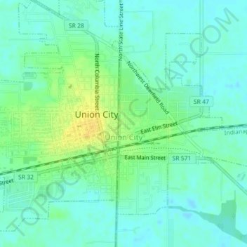
Name: Union City topographic map, elevation, terrain.

Location: Union City, Darke County, Ohio, United States (40.19103 -84.80617 40.21083 -84.77503)

Average elevation: 1,093 ft

Minimum elevation: 1,066 ft

Maximum elevation: 1,142 ft

Darke County trails, hiking, mountain biking, running and outdoor activities

Other topographic maps

Click on a map to view its topography, its elevation and its terrain.

Union Corners

United States > Ohio > Darke County

Average elevation: 1,010 ft

Webster

United States > Ohio > Darke County

Average elevation: 991 ft

Horatio

United States > Ohio > Darke County

Average elevation: 1,010 ft

Abbottsville

United States > Ohio > Darke County

Average elevation: 1,050 ft

Hill Grove

United States > Ohio > Darke County

Average elevation: 1,073 ft

Delisle

United States > Ohio > Darke County

Average elevation: 1,053 ft

Gear up for your next adventure:

Solar GPS Watches - Advanced multisport watches with built-in topographic maps
Backpacking Tents - Weight-optimized shelters for multi-day topographic surveys
🧭Outdoor Navigation Book - Learn advanced navigation skills
🔦LED Headlamp - Bright and durable LED headlamp for night navigation
🎒Gear Packing Cubes - Organize your backpack efficiently

As an Amazon Associate, this site earns from qualifying purchases at no extra cost to you.