Geolocate

Webster topographic map

Click on the map to display elevation.

About this map

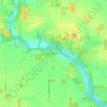
Name: Webster topographic map, elevation, terrain.

Location: Webster, Darke County, Ohio, United States (40.16666 -84.49788 40.20666 -84.45788)

Average elevation: 991 ft

Minimum elevation: 945 ft

Maximum elevation: 1,030 ft

Darke County trails, hiking, mountain biking, running and outdoor activities

Other topographic maps

Click on a map to view its topography, its elevation and its terrain.

Yorkshire

United States > Ohio > Darke County

Average elevation: 981 ft

Rossburg

United States > Ohio > Darke County

Average elevation: 1,040 ft

North Star

United States > Ohio > Darke County

Average elevation: 1,004 ft

Ithaca

United States > Ohio > Darke County

Average elevation: 1,043 ft

Gordon

United States > Ohio > Darke County

Average elevation: 1,040 ft

Hollansburg

United States > Ohio > Darke County

Average elevation: 1,155 ft

Gettysburg

United States > Ohio > Darke County

Average elevation: 1,010 ft

Castine

United States > Ohio > Darke County

Average elevation: 1,079 ft

Wayne Lakes

United States > Ohio > Darke County

Average elevation: 1,073 ft

Arcanum

United States > Ohio > Darke County

Average elevation: 1,047 ft

Union City

United States > Ohio > Darke County

Average elevation: 1,093 ft

Palestine

United States > Ohio > Darke County

Average elevation: 1,119 ft

Versailles

United States > Ohio > Darke County

Average elevation: 988 ft

Pitsburg

United States > Ohio > Darke County

Average elevation: 1,024 ft

Gear up for your next adventure:

GPS Sports Watch - GPS watch for running, hiking and training
📚Navigation Handbooks - Master the art of reading topographic maps and using a compass
🌡️Handheld Weather Meters - Measure wind, temp, and pressure for safe mountain travel
🧯Portable Fire Pit - Compact fire pit for camping spots
🔊Portable Camp Speaker - Music and alerts at camp

As an Amazon Associate, this site earns from qualifying purchases at no extra cost to you.