Geolocate

Perur topographic map

Click on the map to display elevation.

About this map

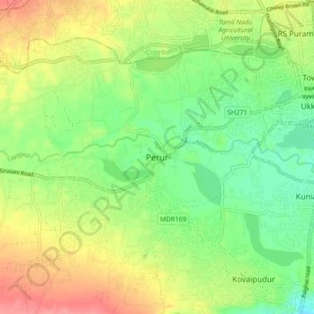
Name: Perur topographic map, elevation, terrain.

Location: Perur, Coimbatore South, Coimbatore, Tamil Nadu, 641010, India (10.93641 76.87418 11.01641 76.95418)

Average elevation: 1,398 ft

Minimum elevation: 1,283 ft

Maximum elevation: 1,552 ft

Other topographic maps

Click on a map to view its topography, its elevation and its terrain.

Ward 65

India > Tamil Nadu > Coimbatore South

Average elevation: 1,316 ft

Pudur

India > Tamil Nadu > Coimbatore South

Average elevation: 1,470 ft

Gear up for your next adventure:

🔦Powerful Headlamps - Ultra-bright hands-free lighting for night navigation
🪄Magnetic Compass - Accurate compass for navigation
🎒Day Hiking Backpack - Lightweight backpack perfect for day trips and outdoor adventures
🔋Rechargeable Batteries - Power up your outdoor devices
GPS Sports Watch - GPS watch for running, hiking and training

As an Amazon Associate, this site earns from qualifying purchases at no extra cost to you.