
Make a donation
Gear up for your next adventure:
As an Amazon Associate, this site earns from qualifying purchases at no extra cost to you.
Palena topographic map
Click on the map to display elevation.
Make a donation
Gear up for your next adventure:
As an Amazon Associate, this site earns from qualifying purchases at no extra cost to you.
About this map
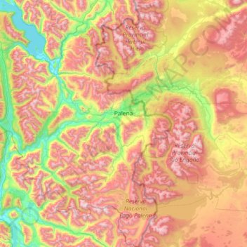
Name: Palena topographic map, elevation, terrain.
Average elevation: 3,114 ft
Minimum elevation: 128 ft
Maximum elevation: 7,064 ft
Make a donation
Gear up for your next adventure:
As an Amazon Associate, this site earns from qualifying purchases at no extra cost to you.
Other topographic maps
Click on a map to view its topography, its elevation and its terrain.
Caleta Andrade
Chile > Región de Los Lagos > Provincia de Palena > Hualaihué
Average elevation: 541 ft
Make a donation
Gear up for your next adventure:
As an Amazon Associate, this site earns from qualifying purchases at no extra cost to you.
Quildaco Bajo
Chile > Región de Los Lagos > Provincia de Palena > Hualaihué > Quildaco Bajo
Average elevation: 112 ft
Villa Vanguardia
Chile > Región de Los Lagos > Provincia de Palena > Chaitén > Villa Vanguardia
Average elevation: 748 ft
Make a donation
Gear up for your next adventure:
As an Amazon Associate, this site earns from qualifying purchases at no extra cost to you.
Volcán Chaitén
Chile > Región de Los Lagos > Provincia de Palena > Chaitén
Average elevation: 2,287 ft
Make a donation
Gear up for your next adventure:
As an Amazon Associate, this site earns from qualifying purchases at no extra cost to you.
Volcán Apagado
Chile > Región de Los Lagos > Provincia de Palena > Hualaihué
Average elevation: 2,841 ft
Make a donation
Gear up for your next adventure:
As an Amazon Associate, this site earns from qualifying purchases at no extra cost to you.