
Kirkburn topographic map
Click on the map to display elevation.
About this map
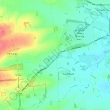
Name: Kirkburn topographic map, elevation, terrain.
Location: Kirkburn, East Riding of Yorkshire, England, United Kingdom (53.96244 -0.53383 54.00781 -0.44168)
Average elevation: 115 ft
Minimum elevation: 46 ft
Maximum elevation: 295 ft
Other topographic maps
Click on a map to view its topography, its elevation and its terrain.
Little Driffield
United Kingdom > England > East Riding of Yorkshire > Driffield
Average elevation: 98 ft
Airedale
United Kingdom > England > East Riding of Yorkshire
Airedale, in conjunction with the Ribble Valley, provides low-altitude passes from Yorkshire to Lancashire through the Aire Gap. It is therefore an important transport route and was a strategically important area historically.
Average elevation: 197 ft
East Cottingwith
United Kingdom > England > East Riding of Yorkshire > East Cottingwith
Average elevation: 26 ft
Malton Lane Plantation
United Kingdom > England > East Riding of Yorkshire > Bugthorpe
Average elevation: 177 ft
Burton Constable Hall
United Kingdom > England > East Riding of Yorkshire > West Newton
Average elevation: 59 ft
Willerby and Derringham Flood Alleviation Scheme
United Kingdom > England > East Riding of Yorkshire > Kirk Ella
Average elevation: 138 ft