Geolocate

Bieben topographic map

Click on the map to display elevation.

About this map

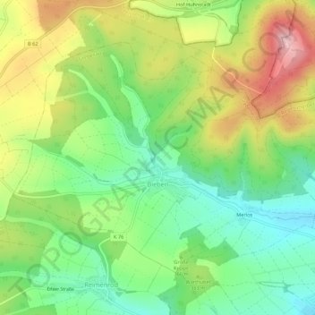
Name: Bieben topographic map, elevation, terrain.

Location: Bieben, Grebenau, Vogelsbergkreis, Hesse, Germany (50.74468 9.41280 50.76970 9.46668)

Average elevation: 1,201 ft

Minimum elevation: 909 ft

Maximum elevation: 1,621 ft

Other topographic maps

Click on a map to view its topography, its elevation and its terrain.

Dick

Germany > Hesse > Vogelsbergkreis

Average elevation: 1,240 ft

Lauterbach

Germany > Hesse > Vogelsbergkreis

Average elevation: 1,184 ft

Gear up for your next adventure:

🛏️Cold Weather Sleeping Bag - Warm sleeping bag for cold conditions
☀️Outdoor Sunscreen - High protection sunscreen for outdoor activities
Backpacking Tents - Weight-optimized shelters for multi-day topographic surveys
📦Dry Bags Set - Waterproof storage for electronics and clothes
📱Heavy-Duty Phone Cases - Drop-proof and waterproof protection for outdoor navigation

As an Amazon Associate, this site earns from qualifying purchases at no extra cost to you.