
Cameron Airpark Estates topographic map
Interactive map
Click on the map to display elevation.
About this map
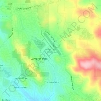
Name: Cameron Airpark Estates topographic map, elevation, terrain.
Average elevation: 1,348 ft
Minimum elevation: 1,112 ft
Maximum elevation: 1,713 ft
Other topographic maps
Click on a map to view its topography, its elevation and its terrain.
Cameron Park
United States > California > El Dorado County > Cameron Park
Cameron Park, El Dorado County, CAL Fire Northern Region, California, United States
Average elevation: 1,342 ft
Cambridge Oaks
United States > California > El Dorado County > Cameron Park
Cambridge Oaks, Cameron Park, El Dorado County, California, 95672, United States
Average elevation: 1,234 ft
Bridlewood Canyon
United States > California > El Dorado County > Cameron Park
Bridlewood Canyon, Cameron Park, El Dorado County, California, 95672, United States
Average elevation: 1,234 ft
Laurel Oaks Park
United States > California > El Dorado County > Cameron Park > Bar J Ranch
Laurel Oaks Park, Bar J Ranch, Cameron Park, El Dorado County, California, United States
Average elevation: 1,247 ft