Geolocate

South Stoke topographic map

Click on the map to display elevation.

About this map

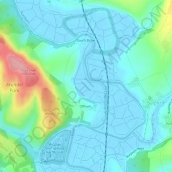
Name: South Stoke topographic map, elevation, terrain.

Location: South Stoke, Arun, West Sussex, England, United Kingdom (50.85995 -0.57172 50.88628 -0.52562)

Average elevation: 85 ft

Minimum elevation: -13 ft

Maximum elevation: 413 ft

Other topographic maps

Click on a map to view its topography, its elevation and its terrain.

Fontwell

United Kingdom > England > West Sussex > Arun

Average elevation: 102 ft

Eastergate

United Kingdom > England > West Sussex > Arun

Average elevation: 39 ft

Barnham

United Kingdom > England > West Sussex > Arun

Average elevation: 20 ft

Shripney

United Kingdom > England > West Sussex > Arun

Average elevation: 10 ft

Eastergate

United Kingdom > England > West Sussex > Arun

Average elevation: 39 ft

Wick

United Kingdom > England > West Sussex > Arun > Littlehampton > Lyminster

Average elevation: 10 ft

Middle Mead

United Kingdom > England > West Sussex > Arun > Littlehampton

Average elevation: 13 ft

Bognor Regis

United Kingdom > England > West Sussex > Arun > Nyetimber

Average elevation: 7 ft

Lidsey Rife

United Kingdom > England > West Sussex > Arun > Felpham

Average elevation: 10 ft

Elmer

United Kingdom > England > West Sussex > Arun

Average elevation: 7 ft

Nyetimber

United Kingdom > England > West Sussex > Arun

Average elevation: 10 ft

North Bersted

United Kingdom > England > West Sussex > Arun

Average elevation: 10 ft

Binsted

United Kingdom > England > West Sussex > Arun > Walberton

Average elevation: 75 ft

Gear up for your next adventure:

🪶LED Camping Lantern - Bright lantern for camp lighting
GPS Sports Watch - GPS watch for running, hiking and training
🧤Hiking Gloves - Protective gloves for rugged trails
🎒Outdoor Daypacks - Lightweight backpacks designed for carrying maps and essential gear
🪶Wildlife Field Guides - Learn animal tracking and species ID

As an Amazon Associate, this site earns from qualifying purchases at no extra cost to you.