
Make a donation
Gear up for your next adventure:
As an Amazon Associate, this site earns from qualifying purchases at no extra cost to you.
Peña Trevinca topographic map
Click on the map to display elevation.
Make a donation
Gear up for your next adventure:
As an Amazon Associate, this site earns from qualifying purchases at no extra cost to you.
Peña Trevinca
Peña Trevinca (en asturleonés, Peña Taravinca; en gallego, Pena Trevinca) es la cumbre más elevada de sierra Segundera, que forma parte del conjunto montañoso de los montes de León, en el macizo Galaico-Leonés (España). Se encuentra en el límite provincial de Zamora y Orense, con una altitud según el Instituto Geográfico Nacional de 2127 m s. n. m., lo que lo sitúa como el pico de mayor altitud tanto de Galicia como de la provincia de Zamora.
Make a donation
Gear up for your next adventure:
As an Amazon Associate, this site earns from qualifying purchases at no extra cost to you.
About this map
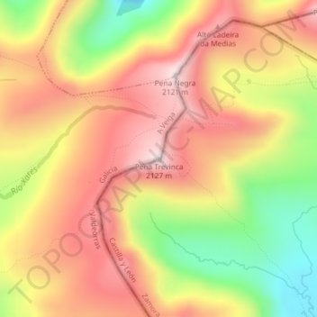
Name: Peña Trevinca topographic map, elevation, terrain.
Location: Peña Trevinca, La Vega, Valdeorras, Orense, Galicia, España (42.24232 -6.79612 42.24242 -6.79602)
Average elevation: 6,240 ft
Minimum elevation: 5,308 ft
Maximum elevation: 6,932 ft
Make a donation
Gear up for your next adventure:
As an Amazon Associate, this site earns from qualifying purchases at no extra cost to you.
Other topographic maps
Click on a map to view its topography, its elevation and its terrain.
Prada
España > Galicia > Valdeorras > La Vega
Al sur, el embalse (altitud media 861 m y bajo sus aguas la antigua parroquia y lugar de Alberguería que estaba a 817 m) y a 11 km por carretera, la capital del municipio, La Vega.
Average elevation: 3,527 ft
Make a donation
Gear up for your next adventure:
As an Amazon Associate, this site earns from qualifying purchases at no extra cost to you.