
Make a donation
Gear up for your next adventure:
As an Amazon Associate, this site earns from qualifying purchases at no extra cost to you.
Valdín topographic map
Click on the map to display elevation.
Make a donation
Gear up for your next adventure:
As an Amazon Associate, this site earns from qualifying purchases at no extra cost to you.
About this map
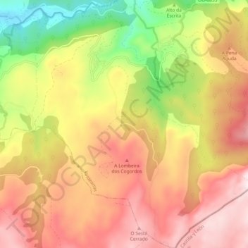
Name: Valdín topographic map, elevation, terrain.
Location: Valdín, La Vega, Valdeorras, Orense, Galicia, España (42.17226 -6.99646 42.23959 -6.91477)
Average elevation: 4,144 ft
Minimum elevation: 2,799 ft
Maximum elevation: 5,246 ft
Make a donation
Gear up for your next adventure:
As an Amazon Associate, this site earns from qualifying purchases at no extra cost to you.
Other topographic maps
Click on a map to view its topography, its elevation and its terrain.
Peña Trevinca
España > Galicia > Valdeorras > La Vega
Peña Trevinca (en asturleonés, Peña Taravinca; en gallego, Pena Trevinca) es la cumbre más elevada de sierra Segundera, que forma parte del conjunto montañoso de los montes de León, en el macizo Galaico-Leonés (España). Se encuentra en el límite provincial de Zamora y Orense, con una altitud según el…
Average elevation: 6,240 ft
Make a donation
Gear up for your next adventure:
As an Amazon Associate, this site earns from qualifying purchases at no extra cost to you.