Geolocate

Suba topographic map

Click on the map to display elevation.

About this map

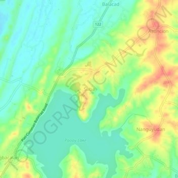
Name: Suba topographic map, elevation, terrain.

Location: Suba, Ilocos Norte, Ilocos Region, 2901, Philippines (18.11016 120.52183 18.15016 120.56183)

Average elevation: 92 ft

Minimum elevation: 20 ft

Maximum elevation: 197 ft

Other topographic maps

Click on a map to view its topography, its elevation and its terrain.

Brgy. 58- Casili

Philippines > Ilocos Norte

Average elevation: 33 ft

Pagudpud

Philippines > Ilocos Norte

The town's topography includes mountains, hills, valleys and flat coastal land.

Average elevation: 233 ft

Paoay Lake

Philippines > Ilocos Norte > Suba

Average elevation: 85 ft

Laoag

Philippines > Ilocos Norte

Average elevation: 135 ft

Gear up for your next adventure:

🧯Portable Fire Pit - Compact fire pit for camping spots
🛰️Handheld GPS Units - Professional satellite navigators for precise backcountry mapping
🔥Plasma Lighters - Windproof lighters that work in any weather condition
🎒Trail Energy Bars - High‑calorie bars for hiking energy
🪶Compact Camp Shovel - Folding shovel for campsite tasks

As an Amazon Associate, this site earns from qualifying purchases at no extra cost to you.